


Cyclone Montha
|
General Studies Paper I: Physical Geography, Important Geographical Phenomena, Cyclones |
Why in News?
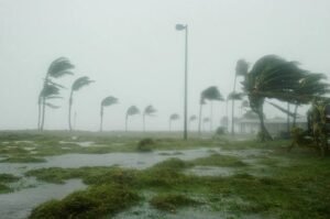
Recently, The IMD issued red alerts that a cyclone named ‘Montha’ approached the coastal areas of Andhra Pradesh, is expected to cross the region between Machilipatnam and Kalingapatnam, near Kakinada, on 29 October 2025.
Highlights of Cyclone Montha
- Formation: The Cyclone Montha formed over the southeast Bay of Bengal during late October 2025, when a low-pressure area deepened into a depression by October 26.
- Path: Cyclone Montha tracked north-northwestwards across the Bay of Bengal, moving towards the coast of Andhra Pradesh. It is forecast to make landfall near Kakinada, on the evening or night of October 28 2025. Prior to landfall, the system was centred some hundreds of kilometres offshore (for example, on October 26 at latitude ~11.3°N & longitude ~87.0°E) as per IMD tracking.
- Naming: The cyclone was named “Montha”, by Thailand in the regional naming list used for cyclones in the Indian Ocean, which means “fragrant flower”. The use of this name aligns with the practice under the India-IMD/ESCAP region, where member countries submit names for tropical cyclones.
- Category: The IMD classified the system as a Cyclonic Storm, and then projected it to intensify into a Severe Cyclonic Storm by the time of landfall on October 28. The classification as ‘severe’ implies significant hazard, including gale-force winds, heavy rainfall and storm surge risk.
- Wind Speed: At landfall, Cyclone Montha is expected to generate sustained wind speeds of 90–100 km/h (≈50–54 knots) and gusts up to 110 km/h (≈60 knots). Prior to that, it had moved slowly across the Bay of Bengal at speeds of about 5–8 km/h while intensifying.
- Possible Affected Areas: The primary area under threat is the coastal belt of Andhra Pradesh, especially between Machilipatnam and Kalingapatnam near Kakinada. Districts such as Kakinada, Konaseema, West Godavari, Krishna, Bapatla, Prakasam and Nellore are now under red alert. Heavy to extremely heavy rainfall (including over 210 mm in 24 h in some zones) is forecast for Rayalaseema region and coastal Andhra between October 27–29. Neighboring states including Odisha, Tamil Nadu, Telangana and even parts of Chhattisgarh, Jharkhand will also face some impact.
Climatic Factors Behind Its Formation
- Sea-Surface Temperatures: The surface of the southeast Bay of Bengal carried warm waters of around 29 °C when the system developed. Warm waters provide energy via evaporation and rising moisture that feed into storm-cloud systems. The high sea-surface temperature acted like a heat-engine that supported the deepening of the low-pressure area into a cyclonic system.
- Monsoon Withdrawal Timing: The South‑West Monsoon officially withdrew from all of India on 16 October 2025. After withdrawal, the wind patterns over the Bay changed and north-easterly flows began over the south-eastern Indian peninsular region. The transition left residual moisture and instability, which served as a pre-condition for Cyclone Montha’s genesis.
- Upper Air Circulation: The low-level winds over the Bay and the adjoining southern peninsular area turned easterly or north-easterly. Higher-level circulations also featured an upper-air cyclonic circulation over the southeast Bay of Bengal and adjoining sea. This kind of circulation helped consolidate convection and allowed a low-pressure area to persist and intensify.
- Weakening of Shear: For a tropical cyclone to grow, the vertical wind shear must be low so the storm’s core remains intact. In the situation of Montha, the upper-air environment over the southeast Bay presented favourable conditions: low shear, strong convection, and good outflow aloft. The combination of specific upper-air structure allowed the low-pressure area.
|
What is a Cyclone?
|
Monitoring of Cyclone in India
- The India Meteorological Department (IMD) is the main national agency responsible for cyclone tracking and forecasting. It monitors both the Arabian Sea and the Bay of Bengal, where most storms originate.
- IMD operates as the Regional Specialized Meteorological Centre (RSMC) for the North Indian Ocean, recognized by the World Meteorological Organization (WMO). The IMD issues bulletins, cyclone alerts, and landfall warnings to all affected countries in the region.
- The department provides six-hourly updates when a cyclone is active and shares intensity forecasts, probable track, and expected landfall time.
- The RSMC, New Delhi, covers eight countries, including India, Bangladesh, Myanmar, Pakistan, Sri Lanka, Maldives, Thailand, and Oman.
- India uses a combination of modern tools to observe and study cyclones. The IMD uses INSAT-series satellites for real-time monitoring of cloud patterns and storm movement. The INSAT-3D and INSAT-3DR satellites provide high-resolution images every 15 minutes.
- The department also uses Doppler Weather Radars (DWRs) installed along the coastline to detect rainfall intensity and wind speed near the surface. As of 2025, India operates more than 37 Doppler radars in coastal and inland regions.
- The IMD follows a systematic warning system with four main stages to alert authorities and the public. Each stage uses color codes—green, yellow, orange, and red—to show increasing levels of threat and urgency.
- The IMD uses both global and regional numerical weather prediction models. These include the Global Forecast System (GFS), Hurricane Weather Research and Forecasting (HWRF) model, and the Multi-Model Ensemble (MME) approach.
- Cyclone monitoring in India is supported by cooperation with other international agencies. The IMD exchanges data with the Joint Typhoon Warning Center (JTWC), Japan Meteorological Agency (JMA), and UK Met Office.
- It also follows guidelines of the WMO/ESCAP Panel on Tropical Cyclones for naming and data exchange.
- The IMD shares information with the National Disaster Management Authority (NDMA) and National Disaster Response Force (NDRF) for immediate action. Coastal districts receive alerts directly from the Cyclone Warning Centres (CWCs) located in Chennai, Visakhapatnam, Bhubaneswar, Ahmedabad, and Mumbai.
|
Also Read: Cyclone Alfred |