

Assam flood situation improved slightly on Wednesday, 08 July, with major rivers receding, reducing the affected population to 1.7 million across 26 districts. The total death toll from this year’s floods, landslides, and storms has risen to 92, with 84 deaths due to the floods alone, according to the Assam State Disaster Management Authority (ASDMA).
Why Assam Flood in the News?
- The flood situation in Assam improved marginally on Wednesday (08 July) with water levels of major rivers showing a receding trend, reducing the affected population to 1.7 million across 26 districts, according to an official bulletin.
- Vast tracts of land, however, remain inundated with sporadic rainfall reported from several districts.
- Seven deaths were reported on Tuesday (09 July) with two in Cachar and one each in Dhubri, Dhemaji, South Salmara, Nagaon and Sivasagar, according to the Assam State Disaster Management Authority (ASDMA).
- The death toll in this year’s floods, landslides and storms increased to 92 with 79 people losing their lives to the deluge alone.
Introduction
- A flood occurs when a large volume of water exceeds its usual boundaries, inundating areas that are typically dry.
- A flood is an overflow of water that submerges land that is usually dry. It can result from various natural and human-made factors, including heavy rainfall, river overflow, coastal storms, dam breaks, and poor urban drainage systems.
- Floods can cause significant damage to property, infrastructure, and ecosystems, and pose a risk to human health and life.
Types of Floods
- River Floods: Occur when rivers overflow their banks due to excessive rainfall or snowmelt. This type of flooding can affect vast areas and cause extensive damage.
- Flash Floods: These are sudden and intense floods that happen quickly, usually within a few hours of heavy rainfall or a sudden release of water (e.g., dam or levee break). They are particularly dangerous because of their swift onset.
- Coastal Floods: Result from storm surges, high tides, or tsunamis, leading to the inundation of coastal areas. Hurricanes and cyclones are common causes of coastal flooding.
- Urban Floods: Occur when urban areas experience heavy rainfall that exceeds the capacity of drainage systems, leading to water accumulation on streets and in buildings. Poor infrastructure and inadequate drainage systems exacerbate this type of flooding.
- Pluvial Floods: Caused by rainfall that creates flooding independent of an overflowing water body. It occurs when the ground cannot absorb rainwater quickly enough, leading to surface runoff and localized flooding.
- Groundwater Floods: Happen when the water table rises above the ground surface, often after prolonged periods of rainfall or snowmelt. This type of flooding can persist for extended periods.
- Ice Jam Floods: Occur when chunks of ice build up and obstruct the flow of a river, causing water to back up and overflow onto the surrounding land. This is common in colder climates during the spring thaw.
- Dam Break Floods: Result from the failure of a dam, leading to the sudden release of large volumes of water downstream. This can cause catastrophic flooding and widespread damage.
- Recently, the Assam Disaster Management Authority reported that devastating floods have impacted over 5 million people across 32 of Assam’s 35 districts. Such severe flooding is not uncommon in Assam, which has experienced similar events multiple times over the past century, including in 1934, 1950, 1954, 1955, 1966, 1988, and 2004.
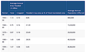
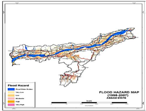
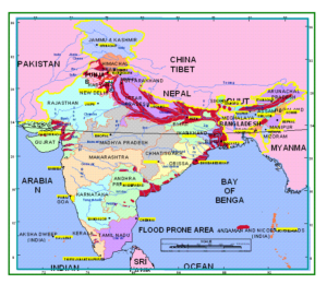
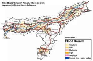
- Assam is crisscrossed by an extensive network of rivers, making it particularly vulnerable to flooding. While 2% of India’s total area is prone to floods, Assam’s flood-prone area is 39.58% of the state’s total area, which is nearly four times the national average. Additionally, the bowl-like topography of Guwahati, shaped by three surrounding hills, makes it especially prone to waterlogging during the monsoon season.
- To better manage future floods, Assam could reinforce embankments, dredge rivers, address river erosion, and implement prudent policy decisions. These recommendations were made by the Parliamentary Standing Committee on Water Resources in its report released in August of last year.
What are the existing Flood Management Mechanisms in India?
- In India, flood management operates on a two-tier system:
- State Level Mechanism
- Water Resources Departments: These departments, along with the State Technical Advisory Committee and Flood Control Board, manage flood-related issues at the state level.
- Irrigation and Public Works Departments: In some states, these departments also handle flood management.
- Union Government Mechanism
- The Union Government has established several organizations and expert committees to assist state governments in comprehensively addressing flood problems:
- Central Water Commission (CWC): This commission was created to promote measures for flood control, water conservation, and the utilization of water resources for irrigation, hydropower generation, flood management, and river conservation across the country.
- Brahmaputra Board: Established under the Brahmaputra Board Act, 1980, this board falls under the Ministry of Jal Shakti. It oversees flood management in the northeastern states within the Brahmaputra and Barak Basin.
- National Disaster Management Authority (NDMA): Formed in 2005 under the chairmanship of the Prime Minister of India, NDMA aims to prevent and mitigate disasters, including floods, by ensuring a coordinated and prompt response to any disaster situation.
Reasons Behind Frequent Floods in Assam
- Natural Causes
- Intensified Monsoon: The monsoon in Northeast India is heavily influenced by the Bay of Bengal. This year, two significant ocean-atmosphere phenomena—La Niña in the Pacific Ocean and a Negative Dipole in the tropical Indian Ocean—worked together to cause heavy rainfall in the Bay of Bengal. Consequently, the region experienced substantial rainfall weeks before the typical monsoon season, leading to early flooding.
- Climate Change: The increase in global temperatures results in a warmer atmosphere, which can hold more moisture. This leads to more intense rainfall and subsequent flooding. Additionally, climate change accelerates the melting of glaciers in the Himalayas, which can increase the severity of flooding in the northeastern region.
- Topography: Assam has an extensive network of rivers, including the Brahmaputra and Barak Rivers, fed by more than 50 The state also receives river water from neighbouring states like Arunachal Pradesh and Meghalaya. The combination of flat topography and large water flow often leads to widespread land inundation.
- Volatile Nature of the Brahmaputra
- The Brahmaputra River is highly braided and unstable throughout the Assam Valley, except for a few locations. This instability is due to the river’s high sediment load and steep slopes. Additionally, the river frequently changes its course, making it nearly impossible to confine within embankments. In some areas, the river’s width has expanded to 15 kilometers due to bank erosion, resulting in the annual loss of approximately 8,000 hectares of land.
- Earthquakes and Landslides
- Assam and other parts of the northeastern region are prone to frequent earthquakes, which often trigger landslides. These landslides and earthquakes introduce a significant amount of debris into the rivers, causing the riverbeds to rise.
- Anthropogenic Factors
- Dams: A major cause of floods in the Assam region is the uncontrolled release of water from upstream dams.
- Unplanned Urban Expansion: Guwahati’s population has surged from an estimated 11,000 people in 1901 to nearly 1 million today. This rapid population growth has led to significant encroachment on wetlands, low-lying areas, and hills, as well as a reduction in forest cover.
- Additionally, inadequate drainage systems contribute to waterlogging in urban areas, which eventually leads to flooding.
Adverse impacts of floods
The adverse impacts of floods are severe and multifaceted. Firstly, floods result in significant loss of life, as seen in the recent Assam floods where the death toll has already reached
- Habitat destruction is another critical consequence, forcing people from both rural and urban areas to abandon their homes and seek shelter. Over 138,000 houses have been either partially or completely damaged.
- Floods also threaten food security by destroying standing crops, damaging granaries, and filling mud houses with river-borne sand.
- Economically, floods cause extensive damage to infrastructure such as buildings, power lines, and communication networks. Blocked roads hinder economic activities, impacting livelihoods and the regional economy.
- Furthermore, floods lead to environmental degradation, resulting in the loss of diverse flora and fauna, as well as the uprooting of trees and the death of animals.
Here are some positive effects of floods:
- Floods contribute to abundant fish populations and rejuvenate floodplain ecosystems throughout the Brahmaputra region, including Kaziranga.
- This landscape has evolved over millions of years due to a dynamic monsoonal climate and powerful rivers carrying sediments eroded from the continuously rising Himalayas.
- Annual floods naturally enrich soils that are prone to depletion.
What measures has the Government implemented for flood control?
- The National Flood Commission (Rashtriya Barh Ayog) submitted a thorough report in March 1980, which included 207 recommendations addressing all aspects of flood-related issues in the country.
- R Rangachari Committee: Established by the Ministry of Water Resources, Government of India in October 2001, tasked with assessing the execution of the National Flood Commission’s recommendations.
- National Water Policy (1987/2002/2012): The Indian Government has placed considerable focus on flood management through this policy.
What are the shortcomings in India’s flood management system?
- The main flaws in flood management in India include the failure to implement recommendations from the National Flood Commission.
- According to a 2017 report by the CAG, many flood-prone states did not identify or mark affected areas as recommended by various committees. Only two out of seventeen audited states verified RBA’s assessments of flood-prone areas, which were supposed to be used for mapping affected regions.
- Additionally, the National Water Policy of 2012 called for the creation of digital elevation models and flood inundation maps based on frequency, yet these have not been developed.
- Furthermore, the Central Water Commission proposed a Model Bill for Flood Plain Zoning back in 1975 to mitigate flood damage by delineating zones susceptible to different flood magnitudes, but only three states—Manipur, Rajasthan, and Uttarakhand—have enacted such zoning acts.
- The CAG report highlighted that implementing these recommendations could have significantly reduced the impact on life and property during disasters like the Uttarakhand (2013) and Chennai (2015)
Here are the recommendations of the Parliamentary Standing Committee on Water Resources:
- Strengthen embankments along rivers: Many flood protection structures in Assam are outdated, constructed in the 1960s along the Brahmaputra and its tributaries, and are now vulnerable.
- Dredging of rivers: It involves clearing sediments and debris from water bodies like lakes and rivers, necessary worldwide to prevent natural sedimentation from clogging channels and harbours.
- Improve alert and forecasting systems: Establish modern weather stations in upstream catchment areas of dams in the North East and install sirens along riverbanks near dams to warn downstream communities during floods.
- Include river erosion in calamity assistance: Advocate for river erosion to be included in the list of calamities eligible for assistance from the National Disaster Response Fund/State Disaster Response Fund.
- Address vacancies in the Brahmaputra Board: Urgently fill vacant positions within the Brahmaputra Board, operational since 1982, to enhance its effectiveness.
- Enact Flood Zoning Bill: Advocate for states like UP, Bihar, West Bengal, Assam, and Odisha to enact the Flood Plain Zoning Bill to regulate activities in floodplains, thereby minimizing damage to life and property.
- Establishing River Basin Organizations (RBOs) was strongly advised in the report. These organizations would offer prompt, short-term, and long-term solutions while promoting the comprehensive development of river basins.
- To address the impact of floods, the report suggests implementing measures like afforestation and revitalizing wetlands.
Way Forward
- Early Warning Systems: Upgrading flood early warning systems is crucial based on past incidents. Providing reliable information ensures better preparedness and alerts for residents.
- Enhanced Infrastructure: Investing in robust infrastructure and drainage systems can manage excess water during heavy rainfall. Installing sluice gates on Brahmaputra’s tributaries is recommended for effective water level control.
- Collaborative Effort: Strengthening cooperation between state and central governments is essential for sustainable flood management. Bilateral data exchange with China is crucial for Brahmaputra river flood prevention.
- Sustainable Land Management: Practices like avoiding floodplain construction and promoting responsible land use can stabilize riverbanks and reduce sediment load.
- Implementing Task Force 2004 Recommendations: Increasing state funds with additional central assistance for embankment maintenance and funding flood control components of reservoir projects.
- Expanded Role and Investment: Central government involvement should be expanded in flood control, with funding schemes ideally in a 90% Central and 10% State ratio instead of the current 75:25.
Explore our courses: https://apnipathshala.com/courses/
Explore Our test Series: https://tests.apnipathshala.com/
Download RNA PDF: https://apnipathshala.com/rna-real-news-and-analysis-11-july-2024/