Assam-Nagaland Tripartite MoU
| General Studies Paper II: Government Policies & Interventions, Inter-State Relations |
Why in News?
Recently, the Centre, Assam, and Nagaland signed a historic tripartite MoU to enable oil and natural gas exploration across more than 1,000 square kilometres of the disputed Assam-Nagaland boundary region.
Highlights of Assam-Nagaland Tripartite MoU
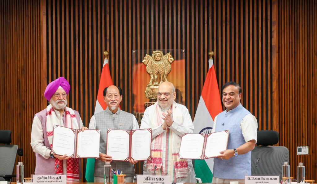
- Parties: The Tripartite Memorandum of Understanding (MoU) on “Mineral Oil Operations in the Assam–Nagaland Boundary Areas” was signed on 11 June 2026 in New Delhi between the Government of India, Government of Assam, and Government of Nagaland.
- The agreement was signed in the presence of Union Home Minister Amit Shah, with participation from Petroleum Minister Hardeep Singh Puri, Assam Chief Minister Himanta Biswa Sarma, and Nagaland Chief Minister Neiphiu Rio.
- Coverage Area: Operations are authorized specifically within the Disputed Area Belt (DAB) along the Assam-Nagaland border.
- The pact unlocks joint exploration and production across more than 1,000 sq km of historically frozen border land.
- It includes six major disputed oilfields/sectors A, B, C, D, E, and F along the 434-km interstate boundary.
- The six sectors are categorized primarily within the Assam districts of Golaghat, Jorhat, Sivasagar, and Karbi Anglong, and intersect major reserved forests.
- It is one of the largest coordinated hydrocarbon development arrangements in Northeast India.
- No Boundary Alteration: The MoU does not settle the underlying inter-state border dispute; Assam’s Original Suit No. 2 of 1988 under Article 131 remains pending before the Supreme Court.
- Exploration & Production: The MoU formally authorizes joint exploration, drilling, extraction, and production activities across the designated boundary areas under a mutually agreed operational mechanism.
- Both Public Sector Undertakings (PSUs) and private energy companies are eligible to undertake exploration and production operations under the framework created by the agreement.
- Equal Revenue Sharing: Any hydrocarbon resources extracted from the disputed belt will be divided equally (50:50) between Assam and Nagaland.
- Potential: Current production from the region is estimated at 1,000–1,500 barrels per day, with projections of a more than tenfold increase after implementation.
- The government estimates that one identified field alone contains recoverable hydrocarbons worth over ₹15,000 crore.
Background of the Assam–Nagaland Border Dispute
The Assam–Nagaland border spans 512.1 km. On the Assam side, the border touches the districts of Sivasagar, Jorhat, Golaghat, Karbi Anglong, and Dima Hasao. On the Nagaland side, districts such as Wokha, Mokokchung, Mon, and Dimapur interface with Assam. It has been the subject of a long-standing territorial dispute:
- 1826 (Treaty of Yandabo): British annexation of Assam altered territorial control in the Northeast, eventually leading to the creation of the Naga Hills District in 1866, which laid the groundwork for future jurisdictional debates.
- A crucial 1925 colonial notification transferred several forested foothill tracts to Assam’s plains administration. Assam recognizes this as the legally valid boundary.
- 1947 (Nine-Point Agreement): Signed between the Naga National Council (NNC) and the Governor of Assam, this historical accord briefly addressed Naga aspirations, including a provision for reviewing all Naga territories administratively transferred to Assam.
- 1960 (16-Point Agreement): This pact provided for the formation of Nagaland as a full state.
- Naga representatives submitted a proposal demanding the “restoration” of ancestral territories absorbed by Assam after 1826.
- Nagaland claims historical ownership of various tracts (roughly 66,000 hectares), including reserved forests in Assam called Disputed Area Belt (DAB).
- 1963: Nagaland statehood was formalized on December 1, 1963, under the Naga Hills-Tuensang Area Act.
- Assam accepted this boundary; however, Nagaland refused to recognize the notified demarcation, arguing it ignored historical boundaries.
- Nagaland laid claim to an estimated 12,488 sq. km of Assamese territory, a massive area spanning nearly 10 Reserve Forests across districts like Sivasagar, Jorhat, Golaghat, and Karbi Anglong.
- 1965: In 1965, the Kakodonga Reserved Forest area became the epicenter of the first violent skirmishes between Assam and Nagaland.
- Naga rebels and settlers encroached upon dense timberlands to create settlements.
- 1971 (Sundaram Commission): The Government of India appointed K.V.K. Sundaram to investigate boundary disputes, leading to four Interim Agreements (1972) that mandated the status quo and restricted new construction in specific reserve forests.
- The Commission conducted local discussions and reviewed colonial mappings until 1976. The final report ultimately upheld Assam’s claims based on constitutional notifications.
- Nagaland rejected the report’s recommendations, claiming that large tracts of historical Naga lands (such as portions of the Sibsagar district and various reserved forests) were unjustly left out.
- 1979: Inter-state tensions peaked with deadly clashes between Rengma and Karbi tribes, around 54 people dead.
- The severe violence forced around 23,500 individuals to flee their homes into relief camps.
- The Central Reserve Police Force (CRPF) was deployed to the Assam-Nagaland border following a high-level meeting between the Chief Ministers of both states on January 28, 1979.
- 1985: The deadliest escalation to date, the Merapani incident (1985), resulted in over 40 deaths, including 28 police personnel.
- The violence halted economic and social interactions between border populations.
- Following the violence, the Shastri Commission was formed under K.V.K. Sundaram’s successor, R.K. Shastri.
- The report emphasized that Assam maintained rightful administrative control over its existing constitutional boundaries. Nagaland rejected the findings.
- 1997 (Pillai Commission): Led by K.P.S. Pillai, the commission submitted its report recommending boundary demarcations based on previous historical and constitutional accords.
- Assam strongly opposed the panel’s findings and rejected the report because it suggested altering the 1963 constitutional boundaries.
- Nagaland also rejected the report, as its leadership felt the recommendations favored Assam’s historical claims and ignored Naga assertions over ancestral lands.
- Due to the failure of these commissions, Assam filed an official lawsuit (Original Suit No. 2 of 1988) under Article 131 in the Supreme Court of India. The dispute remains pending under judicial scrutiny.
- 2006 (Supreme Court Commission): The Supreme Court of India appointed a Local Commission to precisely identify and map the physical boundaries between the two states to find a judicial resolution.
- Initially headed by Justice S.N. Variava, the commission was later succeeded by Justice (Retd.) Tarun Chatterjee.
- The mapping and recording of evidence (such as the 33 topo-sheets from the Survey of India) are ongoing in the Supreme Court trial stage.
- 2023: Chief Ministers of both states held talks in New Delhi in the presence of the Union Home Minister.
- They reached in-principle agreements on oil exploration along the border and initiated a framework to settle outstanding disputes.
Significance of Assam-Nagaland Tripartite MoU
- Unlocking Stalled Resource Development: The MoU removes a major bottleneck that had prevented hydrocarbon development in the Assam–Nagaland border belt for over 30 years.
- The agreement converts a dormant resource zone into an operational energy corridor.
- India’s Energy Security: A key significance lies in enhancing domestic crude oil and natural gas production, reducing dependence on imported hydrocarbons.
- India seeks to expand indigenous energy sources amid rising consumption, this is positioned as an important step toward energy self-reliance.
- Energy Growth Hub: The MoU elevates the Northeast from a frontier region to a strategic energy zone.
- Assam already possesses nearly 22% of India’s crude oil reserves and about 15% of natural gas reserves.
- The agreement enables integrated regional resource development.
- Accelerating Exploration: The pact creates momentum for exploration in the Assam–Arakan Basin and the Naga-Schuppen Belt, two hydrocarbon-rich geological systems.
- These areas are considered among India’s most promising yet underutilized energy provinces.
- Large-Scale Capital Investment: By reducing regulatory and territorial uncertainty, the agreement improves investor confidence.
- Exploration and production projects require substantial investments in drilling, seismic surveys, pipelines, and processing infrastructure, making the MoU a catalyst for long-term energy-sector capital inflows.
FAQs:
1. What is the Assam-Nagaland Oil MoU?
A tripartite agreement between the Centre, Assam, and Nagaland enabling joint exploration and production of crude oil and natural gas in Assam–Nagaland boundary areas.
2. Why is the agreement considered historic?
It ends decades of deadlock over hydrocarbon development, unlocks border resources, and establishes a 50:50 sharing framework despite unresolved boundary disputes.
3. How will the MoU benefit Assam and Nagaland?
The pact is expected to boost investment, employment, revenue generation, infrastructure development, and hydrocarbon production while providing certainty for long-term energy projects.
4. What role will oil exploration play in regional development?
Oil exploration will strengthen energy security, attract industries, support local businesses, and create an economic corridor driving growth across Northeast India.
5. What did Neiphiu Rio say about the agreement?
Neiphiu Rio called it a “historic milestone”, saying it reflects mature Assam–Nagaland relations and will benefit present and future generations through shared development.
| Also Read: Arunachal–Assam Boundary Settlement |