| For Prelims – India and World Geography-Physical For Mains: GS I- Important Geophysical phenomenons such as Earthquakes |
Recently, Japan’s meteorological agency recently announced that the chances of intense earthquakes and significant tsunamis along the Nankai Trough are higher than usual.
HIGHLIGHTS of MEGAQUAKES :
An earthquake exceeding magnitude 8 is known as Megaquake.
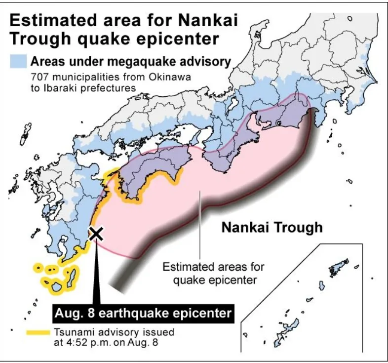
Following a 7.1-magnitude earthquake in southern Japan on August 8, the meteorological agency issued its first-ever “megaquake advisory.”
The probability of severe shaking and significant tsunamis along the Nankai Trough is higher than usual.
The Nankai Trough is an underwater subduction zone, nearly 900 km long, where the Eurasian Plate converges with the Philippine Sea Plate, forcing the latter beneath the former into the Earth’s mantle.
The accumulation of tectonic stress in this region can lead to megaquakes.
Location: The Nankai Trough extends from Shizuoka, just west of Tokyo, to the southern tip of Kyushu Island. This region has experienced catastrophic earthquakes with magnitudes of eight or nine approximately every century or two.
These “megathrust quakes,” which often occur in pairs, have been known to trigger devastating tsunamis along Japan’s southern coastline.
Tremors typically occur in pairs, with the second one often striking within the following two years. The most recent “twin” earthquakes occurred in 1944 and 1946.
– Japan’s Earthquake Research Committee estimates a roughly 70% chance of the next magnitude 8-9 megaquake occurring along the trough within the next 30 years.
– Accurately predicting an earthquake requires detecting a precursory signal from within the Earth that indicates a major quake is imminent.
– Currently, there is no equipment capable of identifying such precursors.
What is a Subduction Zone?
A subduction zone is a location where two of the Earth’s tectonic plates collide, causing one plate to dive or subduct beneath the other. Tectonic plates are sections of the Earth’s rigid outer layer that slowly move across the planet’s surface over millions of years. This movement is a fundamental aspect of plate tectonics, the theory that segments of Earth’s crust slide over the lower mantle, carrying continents along with them.
Subduction zones typically form a horseshoe shape around the edges of the Pacific Ocean, extending offshore from the USA, Canada, Russia, Japan, and Indonesia, down to New Zealand and the southern coast of South America, an area known as the “Ring of Fire.” These zones are the most seismically and volcanically active regions in the world, accounting for more than 80% of the largest earthquakes and most of the planet’s active volcanoes.
WHAT IS AN EARTHQUAKE?
An earthquake, simply put, is the shaking of the Earth, a natural event caused by the release of energy that creates waves spreading in all directions.
– These vibrations, known as seismic waves, are generated by earthquakes and travel through the Earth, where they are recorded by instruments called seismographs.
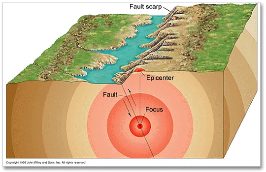
-The point where energy is released during an earthquake is known as the focus or hypocenter. The energy waves generated from this point travel in various directions and eventually reach the Earth’s surface.
– The point on the surface closest to the focus is called the epicentre. It is the first location to experience seismic waves and is situated directly above the focus.
Measuring Earthquakes
Seismometers are instruments used to measure ground motion, including the seismic waves produced by earthquakes, volcanic eruptions, and other seismic activities. The term “seismograph” is also commonly used to refer to seismometers, although it is more applicable to older models.
The graphical output recorded by a seismometer or seismograph is called a seismogram. (Note: It’s important not to confuse the two; a seismograph is the instrument itself, while a seismogram is the recorded output.)
There are two primary scales used with seismometers: the Mercalli Scale and the Richter Scale.
Mercalli Scale
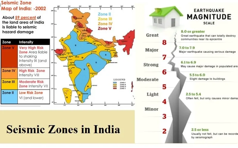
The Mercalli Scale measures the intensity of an earthquake by evaluating its aftereffects, such as how many people felt it and the extent of the destruction caused. The intensity ranges from 1 to 12.
Richter Scale
The Richter Scale measures the magnitude of an earthquake, expressed as absolute numbers from 1 to 10. Each whole number increase on the Richter scale indicates a tenfold increase in the earthquake’s power.
Seismic Waves (Earthquake Waves)
- Seismic waves are energy waves generated by earthquakes or explosions, travelling through the Earth and recorded by seismographs.
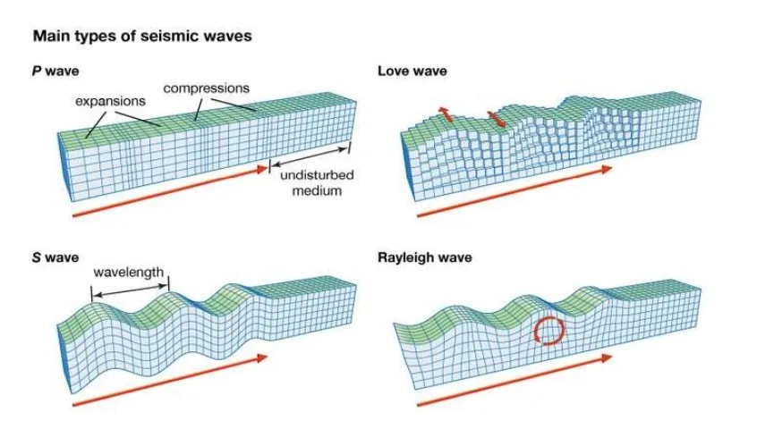
- Earthquake waves are classified into two main types: body waves and surface waves.
- Body waves originate from the release of energy at the earthquake’s focus and travel through the Earth’s interior, hence the name “body waves.”
- There are two types of body waves: P-waves and S-waves.
- P-waves, also known as primary waves, travel the fastest and are the first to reach the surface. They are similar to sound waves and can move through gases, liquids, and solids.
- S-waves, or secondary waves, arrive after a short delay. Unlike P-waves, S-waves can only travel through solid materials.
- When body waves reach the Earth’s surface, they generate surface waves, which move along the surface.
- Surface waves are the last to be detected by seismographs and are more destructive, causing rock displacement and structural collapse.
- Understanding the characteristics of seismic waves has been crucial in helping scientists learn about the Earth’s internal structure.
Effects of Earthquakes
Earthquakes are a natural hazard that can cause significant harm to life and property, especially when they are of high magnitude.
– Ground shaking
– Uneven ground settlement
– Landslides and mudslides
– Fires
– Ground lurching
– Avalanches
– Ground displacement
– Flooding from dam and levee failures
– Structural collapse
– Tsunamis
Earthquakes in India
– India is one of the countries most affected by earthquakes due to the presence of the seismically active young fold mountains of the Himalayas.
The country has been categorized into four seismic zones (II, III, IV, and V) based on scientific data regarding seismic activity, historical earthquakes, and the tectonic structure of the region.
Explore our courses: https://apnipathshala.com/courses/
Explore Our test Series: https://tests.apnipathshala.com/


