


New Definition of the Aravalli Hills
|
General Studies Paper II: Government Policies and Interventions, Biodiversity |
Why in News?
After the Supreme Court‘s approval of the Environment Ministry’s panel recommendation of redefining the Aravalli Hills to limit mining, the opposition parties argue that this will risk severe environmental and public health impacts.
Environment Ministry’s Panel Recommendations on Aravalli Hills
- The panel recommends that a landform be classified as an “Aravalli Hill” only if it rises at least 100 metres above the local relief. Along with the hilltop, its slopes, base, and associated landforms (even if low‑gradient) would also be part of the “hill”.
- Under the new framework, two or more such Aravalli Hills located within 500 metres of each other (measured from the outer boundary of their lowest contour lines) together constitute an “Aravalli Range”. The land between and around such hills — including smaller ridges, valleys, slopes will be regarded as part of the range.
- The recommendation urges the concerned states to use the above criteria — elevation and proximity — to demarcate and map the hills and ranges clearly. The mapping work is to be carried out with support from national geospatial/ survey agencies (like Survey of India) and state forest/geology departments.
- Until a full management and protection plan is ready, the panel recommends halting new mining leases or renewals across the Aravalli‑designated states (Rajasthan, Haryana, Delhi, Gujarat).
- The plan calls for a scientifically framed ‘Management Plan for Sustainable Mining (MPSM)’, to be prepared by the central forestry research agency (Indian Council of Forestry Research and Education, ICFRE). The plan must identify core and inviolate zones where mining will be strictly prohibited. Classify areas where limited mining could be allowed under strict environmental safeguards and only for strategic or critical minerals.
- Also a 2024 technical committee revised the benchmark for identifying Aravalli Hills, changing to a definition requiring a slope of at least 4.57 degrees and a height of at least 30 meters to cover about 40% of the terrain.
Reasons behind the Revised Definition of Aravalli Hills
- Scientific Uniformity: The Ministry argued for a clear, measurable standard to define what counts as “Aravalli Hills.” The proposed benchmark replaces older, inconsistent definitions that varied across states. The goal is to achieve a single uniform definition across all states in the Aravalli Belt.
- Simplify Regulation: A uniform, measurable definition helps regulators clearly identify which landforms are protected under existing mining and environmental laws. This will reduce ambiguity in applying restrictions and would help implement laws in a more consistent way across different states.
- Illegal Mining: Varying state‑wise definitions allowed mining and quarrying — often illegal or unsustainable to persist across low ridges, small hills, and degraded terrains. The new definition aims to limit mining leases to only clearly defined hills, which could help reduce unregulated extraction.
- Hill Height Classification: An internal Forest Survey of India (FSI) assessment found that only 1,048 of 12,081 Aravalli hills (8.7%) in 15 Rajasthan districts are 100 meters or taller, even though the 20m height is the cutoff for being considered a wind barrier. This classification concerns low-lying hills vital for slowing the Thar Desert‘s advance and regulating rainfall.
- Rational Management: With a clear boundary for “Aravalli Hills,” the Ministry can plan a comprehensive management plan for mining and conservation across the range. This would allow zoning areas strictly protected.
- Modernization of Mapping: The redefinition relies on geological and topographic criteria rather than older informal or arbitrary demarcations like FSI’s 3-degree slope yardstick to define Aravalli Hills since 2010. Modern mapping supported by survey agencies can help for better land‑use planning.
Know about the Aravalli Range
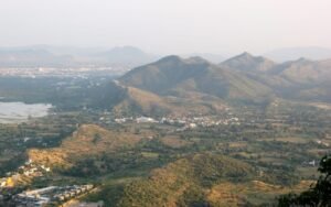
The Aravalli Range is one of the world’s oldest fold-mountain systems, with its origins tracing back to the Proterozoic Era, over 1.5 to 3.2 billion years ago.
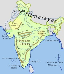
- Location: The Aravalli Range stretches roughly 670 km from near Delhi, through southern Haryana and Rajasthan, to Gujarat. Its width varies between 10 and 100 km, depending on the region.
- Parts: The range divides into two main segments: the northern section around Delhi and Haryana, and the southern section that runs through Rajasthan into Gujarat. The highest point is Guru Shikhar on Mount Abu, rising to 1,722 metres.
-
- Formation: It was formed through a process called orogeny, which involved the collision and crumpling of ancient cratons (stable parts of the Earth’s continental crust). This tectonic activity occurred long before the formation of the Himalayas.
- Topography: The Aravalli ridges stand as a natural barrier between the arid Thar Desert to the west and the fertile plains of eastern Rajasthan and the Indo‑Gangetic region to the east. The range’s ridges and slopes influence local drainage patterns. Several rivers, such as the Banas River, Luni River and others, originate or draw recharge from Aravalli‑fed aquifers.
- Biodiversity: The Aravalli Range sustains diverse ecosystems from dry deciduous forests to scrublands and rocky terrain. The forests have many plant species including drought‑resistant native trees like Acacia, Dhok and Neem, along with medicinal plants. Animal life includes predators like leopards and sloth bears, herbivores, and many bird species.
-
- Historical Significance: The foothills and surroundings of the Aravallis have been home to human civilization for thousands of years, including settlements of the Indus Valley Civilization. The region features numerous historical monuments, such as the Kumbhalgarh Fort, Chittorgarh Fort, and Amber Fort. Ancient people utilized the range for mining and metallurgy, particularly for copper and other minerals.
- Ecological Importance: The Aravalli acts as a natural barrier that obstructs the westward desert’s sand and dust from spreading into the fertile eastern plains. The forests and natural landscapes within the Aravalli range function as a “green lung,” providing essential oxygen and filtering pollutants for heavily populated and polluted areas. The range is instrumental in ensuring water security across the region. It plays a critical role in groundwater recharge, protecting water catchments, and sustaining rivers. The range reduces the impact of hot desert winds and helps stabilize weather patterns in adjoining plains.
Concerns related to the New Aravalli Range Definition
-
- Loss of Ecological Protection: Experts express concern that a new definition of the Aravalli Hills may remove protection from many low-height ridges that still play a vital ecological role. A large share of Aravalli landforms lie below 100 metres in height, supporting biodiversity and groundwater recharge. The new definition may exclude more than 90% of the Aravali Hills from protection, which could expose fragile habitats to future disturbance.
- Increase Activities of Mining: This definition may open more land for mining and real-estate expansion. Official data shows that illegal mining destroyed large parts of Aravalli forests between 1990 and 2020. Many groups fear that newly excluded hills could become vulnerable to quarrying. This could increase dust levels, heat stress and habitat loss in regions.
- Threats to Groundwater: The Aravalli Range supports natural water recharge across semi-arid areas. Removal of tree cover could reduce infiltration and worsen the groundwater crisis. Many villages around Alwar, Gurugram and Aravalli districts rely on natural recharge zones. Any change that weakens this system may harm long-term water security.
- Pollution Risks: Degrading the Aravalli belt may worsen climate issues in the Indo-Gangetic plains. If smaller hill features lose protection, the region may face stronger heat waves. This can intensify pollution levels and could worsen air quality in major cities.
Way Forward
The Supreme Court has accepted the Centre’s new definition but directed the Environment Ministry to prepare a Management Plan for Sustainable Mining in the Aravalli Hills. The Ministry should map vulnerable zones, strengthen monitoring systems, restore degraded areas and set strict limits on extraction. A community-based approach can support local livelihoods while safeguarding the fragile Aravalli ecosystem for future generations.