




Fault Line Threatens China Brahmaputra Dam Project
| General Studies Paper III: Water Resources, India and its Neighbourhood |
Why in News?
Recently, Chinese geologists warned that an active fault beneath China’s proposed Brahmaputra Hydropower Dam Project could heighten earthquake, landslide, and structural risks.
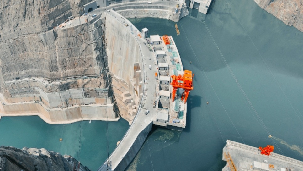
Highlights of China’s Brahmaputra Hydropower Dam Project
- Location: China’s proposed Yarlung Tsangpo (Brahmaputra) Hydropower Project is located in Medog County, Nyingchi Prefecture, Tibet Autonomous Region.
- It is near the Great Bend of the Yarlung Tsangpo River, just upstream of Arunachal Pradesh.
- The river descends nearly 2,000 metres within about 50 km, creating one of the world’s highest hydropower potentials.
- The project lies in a geologically fragile Himalayan zone close to the India–China border.
- Investment: The project is estimated to require an investment of around US$147 billion, making it the costliest hydropower infrastructure project ever undertaken.
- Status: Construction officially commenced in July 2025.
- This project is expected to take over a decade to be completely operational.
- It is being developed by the newly established China Yajiang Group, reflecting Beijing’s long-term strategic commitment.
- Features: It is marketed predominantly as a Run-of-the-River project.
- It leverages the massive 2,000-metre natural elevation drop over a short 50 km stretch of the Grand Canyon to generate kinetic energy.
- The dam system is designed to generate nearly 300 billion kWh (300 TWh) of electricity annually, almost three times the output of the Three Gorges Dam.
- The expected power generation from the dam is around 60,000 megawatts (or 60 gigawatts).
- The project comprises five cascade hydropower stations, making it the world’s largest hydropower complex by electricity generation.
- The project employs advanced cascade hydropower, long diversion tunnels, underground powerhouses and high-head water engineering to exploit the river’s steep gradient.
- To shortcut the loop of the Great Bend, engineers are drilling four massive 20 km long diversion tunnels through the core of the Namcha Barwa mountain.
- Significance: For China, the project strengthens energy security, and promotes economic integration of Tibet.
- It also supports western development and supplies clean electricity to eastern manufacturing hubs.
- The project is embedded in China’s 14th Five-Year Plan, highlighting a strategic balancing act that enhances infrastructure in a sensitive border region.
- The project is expected to generate about 20 billion yuan ($3 billion) annually, which can create new economic opportunities in an underdeveloped area.
- It also aligns with China’s renewable energy goals. This will play a critical role in supporting China’s carbon neutrality target by 2060.
- Under its South-North Water Diversion Project, China can potentially divert water northward, helping water stress areas like Beijing, Hebei, and Tianjin.
Environmental and Geological Concerns of China’s Brahmaputra Mega Dam
- Fragile Geological Setting: The proposed project is situated in the Great Bend of the Yarlung Tsangpo within one of the world’s youngest and most tectonically active mountain systems.
- The region experiences intense crustal deformation due to the Indian and Eurasian plate collision, making it naturally vulnerable to earthquakes, landslides, rockfalls and slope failures.
- Active Fault-Line: Recent reports citing Chinese geologists indicate that parts of the project area lie close to the active Paizhen Fault, which remains tectonically active since the Pleistocene.
- This geological hazard poses significant risks to the structural stability of the dam, surrounding bridges, roads, and tunnels.
- According to the researchers the terrain has a loose structure and weak cohesion.
- The researchers urge engineers to strictly reinforce slope stability and fortify construction zones to prevent catastrophic failures.
- High Earthquake Risk: The eastern Tibetan Plateau has witnessed several moderate-to-strong earthquakes in recent decades.
- 2017 Milin Earthquake, the magnitude 6.9 event occurred at the northern end of the Paizhen Fault line, proof of the fault’s continuing modern seismic potential and activity.
- In this highly seismic Himalayan collision zone, fault movement and future earthquakes will easily trigger massive collapses.
- Construction in such a seismic zone raises concerns over dam safety, reservoir stability and emergency preparedness, requiring advanced seismic-resistant engineering standards.
- Landslide and Sediment: Steep valleys, fragile rocks and intense monsoon rainfall make the basin highly susceptible to landslides.
- Large slope failures can block rivers, generate debris flows and increase sediment loads, affecting both dam operations and downstream river morphology.
- Ecological Sensitivity: The lower Yarlung Tsangpo Grand Canyon supports globally significant temperate forests, alpine ecosystems and endemic flora and fauna.
- Large-scale construction, roads and tunnelling may fragment habitats and disturb biodiversity in one of Asia’s richest ecological landscapes.
- River Ecosystem Impact: Hydropower regulation can modify natural river flow, water temperature and sediment transport. Such changes may influence aquatic biodiversity, fish migration and downstream floodplain ecology.
India’s Concerns and Response to China’s Brahmaputra Mega Dam
- Concerns: India is concerned that this could influence seasonal river flows, particularly during the lean season.
- Any earthquake or accidental structural failure could increase downstream flood risks, particularly in the Siang and Brahmaputra valleys.
- The Brahmaputra’s annual sediment replenishes fertile floodplains; significant alterations could affect biodiversity and livelihoods across Northeast India.
- India views the mega dam as a potential geopolitical leverage point during periods of bilateral tension, particularly because there is no comprehensive water-sharing treaty governing the Brahmaputra.
- In 2002, India and China signed an MoU to exchange hydrological data, this was extended multiple times, but the MoU expired in 2023.
- The Expert Level Mechanism (ELM), set up in 2006, was intended to address water-related issues but it has proven ineffective in resolving major disputes or addressing water-sharing challenges.
- Both India and China aren’t signatories to the international UN Watercourses Convention (1997).
- The absence of this global legal framework complicates transboundary watercourse and water cooperation.
- Absent this, there are no international obligations to ensure equitable sharing of rivers that flow across borders.
- Response: The Ministry of External Affairs (MEA) has formally conveyed India’s concerns to China and issue has been raised through bilateral diplomatic channels and official engagements.
- India has consistently pressed China to resume hydrological data sharing, ensure technical transparency, and consult downstream countries.
- India continuously monitors satellite imagery, river hydrology, and infrastructure developments in Tibet to assess possible impacts on water security and disaster preparedness.
- India is advancing the proposed Siang Upper Multipurpose Project in Arunachal Pradesh to enhance hydropower generation, flood moderation, and strategic water security.
- India is improving flood forecasting systems, disaster resilience, interstate coordination, and basin-level planning in the Brahmaputra region while advocating rules-based transboundary river governance.
FAQs:
1. What is China’s Brahmaputra Dam project?
A 300 TWh annual run-of-river hydropower project on Tibet’s Yarlung Tsangpo River.
2. Why has a Chinese study raised concerns about active fault risks?
It identified the active Paizhen Fault, increasing earthquake, landslide, and infrastructure safety concerns.
3. Where is the Brahmaputra mega dam being constructed?
Near the Great Bend in Medog County, Tibet Autonomous Region, China.
4. How could seismic activity affect the dam project?
Earthquakes could trigger landslides, tunnel damage, structural instability, and operational disruptions.
5. Why is the Brahmaputra Dam significant for India?
It affects downstream water security, ecology, disaster risks, and strategic interests.
6. What environmental concerns are associated with the project?
Potential habitat loss, altered sediment flow, biodiversity decline, and ecosystem disruption.
7. How could the dam impact downstream countries?
It may alter river flows, sediments, flood risks, and ecological conditions downstream.
Disclaimer: Information in this article is based on official announcements and public records. Regulations and implementation details may evolve over time.