



ISRO Navigation Satellite NVS03 Launch, Strengthening India’s NavIC System
| General Studies Paper III: Space Technology, ISRO Achievements |
Why in News?
Recently, Indian Space Research Organisation (ISRO) successfully launched the navigation satellite NVS-03, enhancing India’s strategic navigation autonomy.
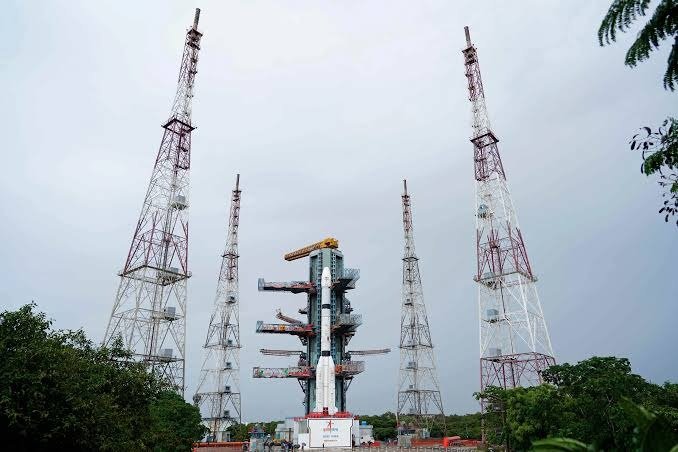
ISRO Navigation Satellite NVS03 Launching Highlights
- Mission Launch: The Indian Space Research Organisation (ISRO) successfully launched the NVS-03 navigation satellite on 30 October 2026 from the Second Launch Pad (SLP), Satish Dhawan Space Centre (SDSC-SHAR), Sriharikota, Andhra Pradesh.
- The scheduled liftoff took place at 11:51 PM IST. ISRO began the approximately 24-hour countdown at 11:51 PM on 29 October.
- Launch Vehicle: The satellite was carried into space by the GSLV-F18 rocket, completing the 20th flight of India’s Geosynchronous Satellite Launch Vehicle.
- This three-stage vehicle utilized a solid motor with liquid strap-on boosters for its first stage, a liquid propulsion stage for its second, and a cryogenic upper stage for final precise insertion.
- It is an approximately 50-metre-tall rocket and has a lift-off mass of around 420 tonnes.
- Mission Objectives: The central objective is to ensure continuity of NavIC services and improve the availability of Positioning, Navigation and Timing (PNT) services.
- Satellite Deployment: The primary flight phase from liftoff to separation was brief, spanning exactly 18.46 minutes.
- GSLV-F18 successfully injected NVS-03 into its designated Geosynchronous Transfer Orbit (GTO).
- The planned injection orbit had a perigee of approximately 170 km, an apogee of 37,023 km and an inclination of 20.75 degrees.
- Milestone: This mission made history as the first instance where ISRO kept the satellite’s pyro valves open during the launch phase.
- This operational adjustment was directly implemented to mitigate previous activation anomalies.
- The flight recorded a historic engineering turnaround time of only 56 days between two successive GSLV missions.
- This marks the shortest operational interval achieved by ISRO for the GSLV family.
What is Navigation Satellite NVS-03?
- About: Navigation Satellite NVS-03 (also designated as IRNSS-1L) is a next-generation regional navigation satellite built to provide accurate Position, Velocity, and Timing (PVT) data.
- It serves as the twelfth spacecraft overall in the Navigation with Indian Constellation (NavIC) network.
- It is the third satellite in India’s second-generation NavIC satellite series.
- It is positioned in a high geosynchronous orbit at 111.75° East longitude.
- Developed By: The satellite was completely designed, manufactured, and operated by the Indian Space Research Organisation (ISRO).
- Key domestic facilities collaborated on its hardware, with the Space Applications Centre (SAC) in Ahmedabad engineering the crucial electronic navigation payloads. Meanwhile, the U.R. Rao Satellite Centre (URSC) in Bengaluru spearheaded the fabrication of the main spacecraft bus structure.
- Need: India urgently required this launch to restore independent 3D positioning capabilities which had temporarily dropped offline.
- A basic navigation system mandates a minimum threshold of four active operational satellites to resolve latitude, longitude, and altitude.
- Due to successive atomic clock failures on older first-generation platforms and the recent propulsion failure of NVS-02, the operational network had depleted to just three satellites.
- A basic navigation system mandates a minimum threshold of four active operational satellites to resolve latitude, longitude, and altitude.
- Features:
- It has an approximate mass of 2,250 kg. It carries navigation payloads and precision timing equipment.
- The spacecraft integrates a highly precise, homegrown rubidium atomic clock built locally by SAC Ahmedabad.
- Navigating space requires absolute synchronized time tracking down to nanoseconds, as minor drifting results in massive distance errors on Earth.
- Transitioning to domestic timing hardware directly protects the constellation from the premature imported clock failures that plagued early generation models.
- NVS-03 upgrades consumer accessibility by broadcasting a new open L1 frequency signal alongside legacy L5 and S bands.
- Because the common L1 band matches standard worldwide GPS frequencies, it permits direct interoperability with low-power commercial electronics.
- This lets everyday consumer devices like smartwatches, fitness trackers, and smartphones native-map the Indian grid.
- The navigation payload supports two separate service tiers optimized for open public use and high-security operations.
- The Standard Positioning Service (SPS) delivers reliable, open civilian location data with a precision mapping accuracy of 5 to 10 meters.
- The highly encrypted Restricted Service (RS) is reserved strictly for tactical military defense networks and authorized government infrastructure.
- Engineered using ISRO’s robust I-2K satellite bus platform, the 2,232 kg vehicle features a long-term 12-year design life.
- This extended duration improves upon the original 10-year limit of first-generation spacecraft.
Significance of NVS-03 for India’s Navigation Infrastructure
- The launch strengthens NavIC, India’s independent regional satellite navigation system, formerly known as the Indian Regional Navigation Satellite System (IRNSS).
- By injecting this, ISRO has restored the critical 4-satellite threshold mandatory for basic positioning services.
- NavIC was developed by the Indian Space Research Organisation (ISRO).
- Architecture & Satellites: The system’s space segment consists of a constellation of 7 active satellites (plus ground backups):
- 3 Geostationary (GEO) satellites placed over the Indian Ocean.
- 4 Geosynchronous (GSO) satellites operating in pairs in inclined orbits.
- They operate in the L5, S, and newer L1 frequency bands.
- Functioning: NavIC works on a trilateration principle.
- The ground station segment monitors the constellation, tracks orbits, and uploads clock corrections.
- The satellites continuously broadcast navigation signals, allowing receivers on Earth to calculate their precise coordinates, velocity, and time.
- By injecting this, ISRO has restored the critical 4-satellite threshold mandatory for basic positioning services.
- The satellite forms a core part of India’s sovereign alternative to foreign global positioning networks.
- It provides an indigenous alternative to foreign navigation systems such as GPS (USA), GLONASS (Russia), Galileo (European Union) and BeiDou (China).
- The system services spanning the entire Indian landmass. It extends its sovereign regional coverage to an area up to 1,500 kilometers beyond India’s geopolitical boundaries.
- It enforces technological sovereignty by offering an encrypted, highly secure Restricted Service (RS) dedicated to military defense.
- Born from the lessons of restricted GPS access during the 1999 Kargil War, it powers independent border surveillance, fleet deployments, and tactical operations.
- This serves as the technological backbone for ballistic missile guidance, precision military targeting, and airforce combat operations.
- It can support ship navigation, fishing vessel tracking, coastal monitoring and maritime safety. Its regional coverage is particularly relevant to India’s extensive coastline and maritime interests in the Indian Ocean Region.
- It empowers coastal security via one-way short-message broadcasting, transmitting localized disaster alerts to fishermen.
- It facilitates mass public infrastructure upgrades, including real-time tracking for 12,000 trains and automated mapping.
- It powers commercial fleet management, geodetic surveying, and local disaster management systems.
- The expansion builds up the national “One Nation, One Time” initiative while driving down costs for domestic navigation chipset manufacturing.
Frequently Asked Questions (FAQs):
1. When was the ISRO NVS-03 satellite launched?
ISRO successfully launched the NVS-03 navigation satellite on October 30, 2026, at 11:51 PM IST.
2. Which rocket was used for the NVS-03 mission?
The satellite was carried into space aboard India’s GSLV-F18 rocket from the Satish Dhawan Space Centre.
3. What is the main purpose of the NVS-03 satellite?
NVS-03 aims to strengthen NavIC’s satellite constellation, improve service continuity and enhance India’s indigenous navigation capabilities.
4. How does India’s NavIC system work?
NavIC satellites transmit precise timing and orbital data, enabling compatible receivers to calculate their geographical position and time.
5. How is NavIC different from GPS?
NavIC is an Indian regional navigation system, whereas GPS is a US-operated global navigation system.
Disclaimer: Information in this article is based on official announcements and public records. Details may evolve over time.
| Also Read: ISRO GSLV-F17 EOS-05 Launch Success |