


India Strategic Power Hub Great Nicobar Island
|
General Studies Paper II: Government Policies & Interventions, Development |
Why in News?
India’s Great Nicobar Island (GNI) Project is a massive infrastructure initiative aimed at transforming India’s southernmost tip into a premier trans-shipment, defence, and economic hub.
India’s Great Nicobar Island (GNI) Project
- About: The Great Nicobar Project is a mega infrastructure plan to develop the southernmost tip of India into a strategic hub.
- Conceived by NITI Aayog in 2021, the project is officially titled the Holistic Development of Great Nicobar Island.
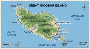
- Location: The development is situated on Great Nicobar Island, the largest in the Nicobar archipelago.
- Key activities center around Galathea Bay on the southeastern coast.
- This site is just 90 nautical miles from Sumatra, Indonesia, and sits at the mouth of the Malacca Strait.
- The project involves lands of Galathea Bay, Pemmaya Bay, and Nanjappa Bay.
- Total Land: The project covers a total area of 166 sq km, which is about 18% of the island.
- This includes 130 sq km of forest land and roughly 35 sq km of revenue land.
- Significant land reclamation of about 4.9 sq km is also planned for the port and airport.
- Agencies: The Andaman and Nicobar Islands Integrated Development Corporation (ANIIDCO) is the main nodal agency for execution.
- NITI Aayog serves as the conceptual architect.
- Other critical partners include Ministry of Ports, Shipping and Waterways and the Airport Authority of India for specific technical components.
- Total Investment: The project has an estimated cost of approximately ₹92,000 crore.
- Funding is planned through a mix of government support and Public-Private Partnership (PPP) models.
- The first phase alone requires an investment of nearly ₹18,000 crore for foundational infrastructure.
- Transshipment Terminal: The Galathea Bay International Container Transshipment Terminal (ICTT) is the project’s anchor.
- It is designed to handle 16 million TEUs (Twenty-foot Equivalent Units) at full capacity.
- The natural water depth of over 20 meters allows it to accommodate the world’s largest container ships.
- Greenfield International Airport: A dual-use International Airport is planned to serve both civilian and military needs.
- It will have the capacity to handle 4,000 peak-hour passengers.
- Integrated Urban Township: The project includes a Greenfield Township spanning about 149 sq km.
- It is designed to house a projected population of 3.5 lakh residents by 2050.
- This urban cluster will include residential areas, commercial zones, and dedicated space for logistics.
- Power Generation Infrastructure: To support the new city, a 450 MVA gas and solar-based power plant will be built.
- It will occupy approximately 0.39 sq km of land near the port complex.
- Development Timeline: The master plan is a long-term vision spanning 30 years.
- Phase 1 construction is targeted for completion by 2035.
- Successive phases will continue through 2047, aligning with India’s “Amrit Kaal” vision for advanced national infrastructure.
- Governance Status: The project received Stage-I forest clearance in 2022 and has been upheld by the National Green Tribunal (NGT) as of February 2026.
- It operates under the EIA Notification 2006 and includes specific mandates for tribal welfare and wildlife corridors to ensure regulated growth.
Why Great Nicobar Project is Called India’s Strategic Power Hub?
- Proximity to Chokepoints: The island sits just 40 nautical miles from the Malacca Strait, a vital global shipping lane.
- Over 94,000 ships pass through this area every year, carrying 30% of the world’s trade.
- The location allows India to monitor China’s energy lifeline, as over 80% of China’s oil imports pass through Malacca.
- This location allows India to monitor sea traffic and energy supplies efficiently in real-time.
- Military Surveillance Reach: The development includes a dual-use military-civilian airport designed for long-range operations.
- It strengthens the Andaman and Nicobar Command, India’s only tri-services unit.
- New surveillance systems help track foreign naval movements, especially in the sensitive Andaman Sea.
- The island acts like an “unsinkable aircraft carrier” for India’s defence strategy.
- Maritime Trade Sovereignty: The Galathea Bay Transshipment Terminal aims to handle 16 million TEUs annually at full capacity.
- Currently, India depends on foreign ports like Singapore and Colombo for cargo.
- This project keeps revenue within India and builds economic sovereignty for the nation.
- It strengthens India’s ability to secure Sea Lines of Communication (SLOCs) and respond to piracy, disasters, and geopolitical tensions.
- Deep Water Advantage: Galathea Bay offers a natural water depth of over 20 meters, which is rare globally.
- This allows the world’s largest container ships to dock directly without needing smaller feeder vessels.
- Such deep-water berths are essential for India to become a leading logistics hub.
- Counter-Strategy: The hub serves as a direct counter to foreign influence and the “String of Pearls” strategy.
- It positions India as a proactive maritime power in the Indian Ocean Region.
- This first line of defense protects India’s vast exclusive economic zone and its continental shelf.
- Integrated Power Security: A 450 MVA hybrid power plant combining gas and solar energy will ensure a constant electricity supply.
- This infrastructure removes the island’s reliance on diesel generators. Reliable energy is critical for maintaining high-tech defense radars and modern port operations.
- Regional Connectivity Bridge: The project aligns with India’s Act East Policy to boost ties with Southeast Asia.
- It acts as a springboard for regional cooperation with neighbors like Indonesia and Thailand.
- The infrastructure supports India’s role as a preferred security partner in the region.
- Financial Revenue Engine: Government estimates suggest the port could generate ₹30,000 crore in annual revenue by 2040.
- It is expected to create over 50,000 jobs for the local and national workforce.
- This economic strength fuels further military modernization and regional development.
- Rapid Deployment Capability: The new Greenfield International Airport will feature a 3,300-meter runway for wide-body aircraft.
- This allows for the rapid deployment of troops, heavy machinery, and disaster relief supplies.
- It ensures India can respond to maritime threats or natural disasters within minutes.
What Are the Major Concerns?
- Massive Forest Loss: The project requires the diversion of roughly 130 square kilometers of pristine tropical rainforest.
- Experts estimate that nearly 9.64 lakh trees will be felled to make way for the township and port.
- This loss of dense canopy is considered irreplaceable due to the unique biodiversity found only on this island.
- Tribal Rights Violations: The Shompen and Nicobarese tribes live in the project area and face displacement.
- The Shompen are a Particularly Vulnerable Tribal Group (PVTG) with a population of only about 300 to 500.
- Critics say the project violates the Tribal Reserve rules and threatens their traditional hunter-gatherer way of life.
- Giant Leatherback Turtles: Galathea Bay is one of the world’s most important nesting sites for the Giant Leatherback Turtle.
- Construction of the transshipment port will destroy these nesting beaches.
- Marine biologists warn that the artificial lights and shipping traffic will permanently disrupt the breeding cycles of these endangered creatures.
- High Seismic Risk: Great Nicobar is located in Seismic Zone V, the most active earthquake zone.
- The island dropped by nearly 3 meters during the 2004 Tsunami, causing massive land changes.
- Building a massive infrastructure project on such unstable ground is seen by geologists as a massive financial risk.
- Megapode Habitat Destruction: The Nicobar Megapode, a unique bird that builds mounds to incubate eggs, is at risk.
- Over 70% of its known nests are located within the proposed development area.
- Environmentalists argue that the project will lead to the local extinction of this ground-dwelling species.
- Coral Reef Damage: The dredging for the deep-sea port will damage or kill vast coral reef colonies.
- These reefs act as natural barriers against storm surges and support marine biodiversity.
- Although the government plans to translocate corals, experts note that translocation has a very low success rate.
- Climate Change Vulnerability: As a low-lying island, Great Nicobar is highly vulnerable to rising sea levels.
- Critics argue that building a mega-city on the coast ignores the realities of the climate crisis.
- Large-scale deforestation will also reduce the island’s natural carbon sequestration capacity.
- Flawed Impact Assessment: Many experts have criticized the Environmental Impact Assessment (EIA) for being rushed and incomplete.
- Reports suggest that data on endemic species and water requirements were not fully verified.
- This has led to several petitions in the National Green Tribunal challenging the project’s clearance.
- Invasive Species Threat: Increasing human activity and shipping will likely introduce invasive species to the island.
- These non-native plants and animals can destroy the local food chain. The influx of 3.5 lakh people will create waste management issues that the island’s ecosystem cannot handle.
- Sustainability Debate: The project reflects a major conflict between economic growth and environmental protection, with experts warning of long-term ecological costs outweighing short-term gains.
How Is the Government Addressing Challenges?
- Three Monitoring Committees: The government has formed three independent committees to oversee the project.
- These groups monitor pollution levels, biodiversity health, and the tribal welfare of the Shompen and Nicobarese.
- An overarching committee led by the Chief Secretary ensures all rules are followed strictly.
- Compensatory Afforestation Plan: To offset tree loss, the government identified 97.30 sq km of land in Haryana for planting new forests.
- This is required because the islands already have over 75% forest cover.
- Additionally, 2.4 million trees have been planted under the “Ek Ped Maa Ke Naam” campaign.
- Wildlife Movement Corridors: The master plan includes eight dedicated wildlife corridors. These paths allow animals like crocodiles, crabs, and macaques to move safely across the island.
- This design prevents habitat fragmentation and helps maintain the island’s natural ecological flow.
- Turtle Nesting Protection: The western flank of the island remains untouched to preserve Giant Leatherback Turtle nesting sites.
- A specialized research unit by the Wildlife Institute of India (WII) monitors these beaches daily.
- The government also plans a new Leatherback Turtle Sanctuary on Little Nicobar Island.
- Net Tribal Reserve Increase: The government has re-notified 76.98 sq km of land as a new tribal reserve.
- This creates a net addition of 3.912 sq km to the total protected area for tribes.
- These measures ensure the Shompen and Nicobarese maintain their ancestral rights and space.
- Shoreline Erosion Control: The NGT has made the Environment Ministry responsible for preventing shoreline changes.
- Construction must not cause erosion that destroys sandy beaches or bird habitats. This rule protects the island’s coast from the impact of heavy dredging.
- Strict Environmental Clearances: The project follows 42 specific conditions under the EIA Notification 2006. These rules cover air, water, and waste management standards during operation.
- Experts from IIT and NIOT provide regular data to ensure full environmental compliance.
- Endangered Species Sanctuaries: Three new wildlife sanctuaries have been sanctioned for endemic species.
- These include a Megapode sanctuary on Menchal Island and a Coral sanctuary near Meroe Island.
- Two all-weather research stations will track biodiversity changes until at least 2052.
|
Also Read: Tribal Council Resists Land Surrender in Great Nicobar Project |