7.8 Magnitude Earthquake Strikes Philippines
|
General Studies Paper I: Physical Geography, Earthquakes, Disaster Management |
Why in News?
Recently, a powerful 7.8-magnitude earthquake struck off Mindanao in the southern Philippines, triggering tsunami warnings.
7.8 Magnitude Earthquake in Philippines: Key Facts
- Event: A powerful magnitude 7.8 earthquake struck offshore southern Mindanao, Philippines on 8 June 2026, making it one of the strongest earthquakes to hit the country in recent years.
- Epicenter: The earthquake’s epicenter was located near Sarangani Province, roughly 30 km off the Mindanao coast near General Santos City.
- Characteristics: Authorities reported depths ranging from 10 km to about 55 km, indicating a relatively shallow and highly destructive earthquake.
- The strongest recorded intensity reached Intensity VIII (Very Destructive) in parts of Sarangani, while General Santos City experienced Intensity VII shaking.
- Areas Affected: Major impacts were reported in Sarangani, General Santos, South Cotabato, Sultan Kudarat, Davao Occidental, and other Mindanao provinces. Tremors were also felt across parts of the Visayas.
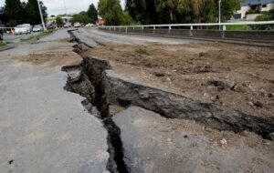
- Impact: Fatality figures remain under verification. Reports indicate at least 15–16 deaths and over 200 injuries, mainly from falling debris, structural collapses, and landslides.
- Several buildings collapsed, including educational and commercial structures.
- Power outages occurred, roads were damaged, and General Santos International Airport temporarily suspended operations, cancelling flights.
- The quake triggered tsunami warnings in the Philippines, Indonesia, and Malaysia. Waves of around 1 metre were recorded locally, while alerts extended to Japan, Taiwan, Guam, and Pacific island territories.
- Thousands of residents in coastal communities were evacuated to higher ground. Schools were suspended and evacuation centres activated.
- Response: President Ferdinand Marcos Jr. ordered immediate rescue and relief operations.
- The City Disaster Risk Reduction and Management Office (CDRRMO) implemented forced evacuations in highly vulnerable coastal barangays.
- The Philippine Institute of Volcanology and Seismology (PHIVOLCS) ordered precautionary evacuations.
- The Philippine Office of Civil Defense and local police units initiated search, rescue, and retrieval operations.
Tectonic Setting of the Philippines
- Location: The Philippines lies within the Pacific Ring of Fire, a 40,000-km seismic belt that accounts for nearly 90% of global earthquakes.
- Its location makes it one of the world’s most earthquake-prone countries.
- Plate Interactions: The archipelago is situated at the convergence of the Philippine Sea Plate, Eurasian/Sunda Plate, and Pacific-related tectonic systems.
- Continuous plate movement generates intense crustal stress and frequent earthquakes.
- Double Subduction System: The Philippine Trench and East Luzon Trench operate on the eastern side, while the Manila, Negros, Sulu, and Cotabato Trenches lie on the western side, unique feature is its double subduction geometry, producing powerful earthquakes and tsunamis.
- Fault System: The Philippine Fault System (PFS) extends about 1,200–1,250 km from Luzon to Mindanao.
- This major strike-slip fault has generated numerous destructive earthquakes and remains one of the country’s most significant seismic hazards.
- Earthquake-Prone Regions: The highest-risk areas include Luzon, Metro Manila, Bicol, Eastern Visayas, Leyte, Surigao, Davao Region, Cotabato, and Mindanao’s eastern coast, where active faults and trenches are concentrated.
- The West Valley Fault (Marikina Valley Fault System) threatens over 14 million residents in Metro Manila. Studies project catastrophic losses if a major earthquake strikes this densely populated region.
- Earthquake Frequency: The Philippines records approximately 826 earthquakes annually on average, one of the world’s most active tectonic environments.
- Earlier Earthquakes: The 1976 M 8.0 Moro Gulf Earthquake remains the deadliest in Philippine history, causing a devastating tsunami and killing an estimated 5,000–8,000 people.
- The 1990 Luzon Earthquake M 7.8 caused around 1,600 deaths, widespread infrastructure collapse, landslides, and economic losses across northern Luzon.
- Recent events include the 1918 Celebes Sea Earthquake (M 8.3), the 2013 Bohol Earthquake (M 7.2; 222 deaths), the 2019 Mindanao Earthquake sequence, and the 2025 Cebu Earthquake (M 6.9; over 60 deaths), demonstrating the country’s persistent seismic vulnerability.
|
What is an Earthquake?
|
|
FAQs: Q1. Where did the 7.8 magnitude earthquake strike in the Philippines? Q2. Was a tsunami warning issued after the earthquake? Q3. How severe was the damage caused by the earthquake? Q4. Why does the Philippines experience frequent earthquakes? |
|
Also Read: Earthquake in Afghanistan |