Balirajgarh Site Excavation
|
General Studies Paper II: Historical Place, Government Policies & Interventions |
Why in News?
Recently, Archaeological Survey of India (ASI) has begun excavation work at the Balirajgarh site in Bihar’s Madhubani district, aiming to uncover remains of the ancient Mithila civilization, which may reveal over 2,000-year-old historical and cultural insights.
Know About Balirajgarh Site
-
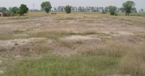
- Intro: Balirajgarh is an important archaeological site and ancient fortified settlement located in Bihar, associated with the early Mithila civilization.
- Location: The site is situated in the Madhubani district of Bihar, within the Mithila cultural region, which has historically been a major centre of Vedic in ancient India.
- It lies in Balirajpur village of Babubarhi block, forming part of a centrally protected archaeological zone, indicating its national importance.
- Discovery: The site was first identified in 1884 by George A. Grierson, marking its recognition in colonial archaeological studies and later inclusion in systematic research.
- Historical Background: It dates back to around 2nd century BCE or earlier. Balirajgarh dates back to around 200 BCE (Shunga period), though evidence suggests pre-Mauryan and Iron Age origins, making it one of the earliest urban centres in eastern India.
- Scholars like Dilip Chakrabarti propose that this site may represent the ancient capital of the Videha kingdom, historically linked with King Janaka and Vedic traditions.
- Excavations have revealed a five-phase cultural sequence including NBPW phase, Shunga, Kushana, Gupta, and Pala periods.
- Local traditions and folklore identify this historic site as the capital of the legendary ruler King Bali, also known as Raja Bali Ka Garh.
- Status: Declared a site of national importance in 1938 under the Ancient Monuments Act, Balirajgarh gained formal protection, highlighting its historical and cultural value.
- Features:
-
- Fortification Structure: The site is known for its large defensive walls and fortifications, indicating a planned urban settlement with military or administrative significance.
- Archaeological Mounds: Over 20 mounds are spread across the site, representing layers of habitation, each corresponding to different historical phases of occupation.
- Physical Extent: The site spreads across approximately 176 acres (about 1 sq km), consisting of multiple mounds and fortified remains, situated on the fertile Gangetic plains.
- Urban Planning: Evidence suggests a well-developed urban layout, including brick structures and organised settlement patterns, pointing to advanced civic planning in ancient Mithila.
- Water Resource System: A perennial pond within the site indicates an efficient water management system, essential for sustaining long-term habitation.
- Ancient Brickwork: The fortification walls exhibit advanced masonry for their time. The ancient baked bricks found in the structure typically measure approximately 1 foot x 1.5 feet x 4 inches.
- Religious Landscape: Remains of temple structures and continued local traditions like fairs suggest the site functioned as both a religious and socio-cultural centre over time.
- Rampart Construction Phases: The fortifications show three distinct architectural phases. The earliest phase had a mud-brick core with brick revetments, while later phases added brick-concrete ramps.
- Art Objects: Archaeologists discover terracotta figurines and decorative items. These artefacts reflect artistic expression and daily life, indicating cultural richness and skilled craftsmanship.
What is Mithila Civilization?
- Geographical Extent: Mithila civilization covered north Bihar and Terai Nepal. Rivers like Ganga, Kosi, and Gandak supported it. The fertile plains enabled agriculture-based settlements. It represents a Vedic and post-Vedic society.
- Historical Origin: The civilization originated during the later Vedic period (c. 1000 BCE). It emerged as part of Indo-Aryan expansion. It evolved into a major Janapada region.
- Mithila served as the core of the Videha kingdom. King Janaka ruled this region. The kingdom gained fame for spiritual and philosophical leadership.
- Political Structure: The region developed a monarchical system initially. Later, it showed republican features in some areas. Governance included organized administration and taxation.
- Economic Base: The people practiced agriculture as the main occupation. They cultivated rice, wheat, and pulses. Trade networks supported regional economic growth.
- Cultural Development: The society promoted art, music, and traditions. It preserved rich folklore and rituals. Cultural practices influenced later regional identities.
- Mithila became a centre of Upanishadic philosophy. Scholars like Yajnavalkya taught here. The region contributed to spiritual debates and knowledge systems.
- People followed Vedic rituals and yajnas. They worshipped multiple deities. Religion shaped social and moral life.
- The region used early Sanskrit and later Maithili language. It produced religious and philosophical texts. Literature supported knowledge transmission.
- Art: People developed Madhubani (Mithila) painting traditions. They built simple but planned settlements.
|
Archaeological Survey of India (ASI)
|
|
Also Read: The Piprahwa Relics |