



Indonesia Tsunami Warning After Flores Earthquake
| General Studies Paper I: Physical Geography, Earthquakes, Disaster Management |
Why in News?
Recently, Indonesia’s Meteorology, Climatology, and Geophysics Agency (BMKG) issued a high-level tsunami warning on August 15, 2026, following a devastating magnitude 7.7 undersea earthquake that struck the Flores region in East Nusa Tenggara.
Flores Earthquake and Tsunami Threat:
- Geological Setting and Tectonic Profile: Indonesia consists of an archipelago of over 17,000 islands situated directly over the Pacific Ring of Fire. This zone experiences extreme geophysical activity due to the convergence of multiple major tectonic plates:
- The Indo-Australian Plate subducts beneath the Eurasian (Sunda) Plate to the south.
- The Pacific and Philippine Sea Plates exert complex compressional forces from the east and northeast.
- The Indo-Australian Plate moves north and pushes down under the Eurasian plate.
- Eurasian Plate acts as the main overriding continental and block mass in western and central Indonesia.
- The Pacific Plate drives west and southwest, creating intense crust squeezing in eastern regions.
- The Philippine Sea Plate converges westward, adding complex tectonic stress around Maluku and Sulawesi.
- Flores Back-Arc Thrust: The specific region north of Flores Island features an active back-arc thrust fault system.
- Compressional stresses from plate subduction create shallow, highly destructive thrust-faulting earthquakes capable of displacing large columns of seawater.
- Flores is part of the Lesser Sunda Islands, which include: Bali, Lombok, Sumbawa, Sumba and Timor.
- The region forms part of a highly active tectonic environment between the Australian Plate and the Sunda/related tectonic systems.
- Compressional stresses from plate subduction create shallow, highly destructive thrust-faulting earthquakes capable of displacing large columns of seawater.
- Earthquake Parameters and Characteristics:
- Region: At 04:58:23 WIB on 15 August 2026, a strong shallow earthquake struck beneath the waters north of Flores, in Indonesia’s East Nusa Tenggara province.
- Magnitude: The mainshock registered at a powerful 7.7 magnitude on the Moment Magnitude Scale.
- Depth: The hypocenter was exceptionally shallow, clocked between 10 to 15 kilometers deep.
- Shallow earthquakes (less than 70 km deep) do not allow the surrounding crust to absorb energy, causing greater destruction at the surface.
- Epicenter: The epicenter was located in the Flores Sea, roughly 68 km north-northwest of the city of Ende and 30 km from Nagekeo in East Nusa Tenggara province.
- Aftershock Sequence: The initial tremor lasted for about one minute. It was followed by dozens of volatile aftershocks, the strongest registering a 6.1 magnitude.
- Alerts: The BMKG modeling issued tsunami alerts for coastal sectors across the provinces of East Nusa Tenggara, West Nusa Tenggara, and South Sulawesi.
- Impacts and Disaster Assessment:
- Human Casualties: National agencies confirmed at least 47 fatalities, with numbers anticipated to rise as emergency teams reach remote interior villages like Nagekeo.
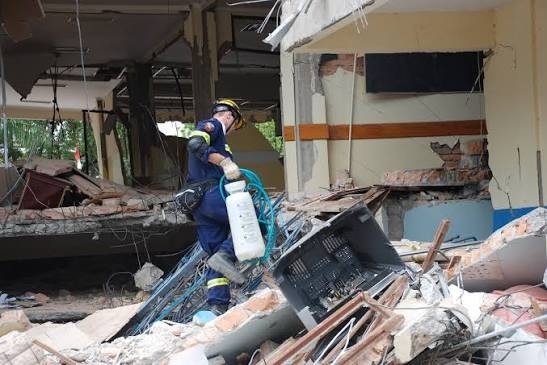
- Structural Losses: Widespread collapses were documented, including the Pelni port terminal waiting room in Maumere.
- Hospitals had to evacuate patients outdoors into makeshift open-air tents due to structural cracks and ongoing aftershocks.
- Infrastructure Collapse: Landslides blocked essential regional roads, while severe power outages and telecommunication disruptions isolated local communities.
- Tidal gauges later recorded minor tsunami waves of less than 1 meter (3 feet) across monitored coastal regencies.
- Disaster Management: This crisis underscores the necessity of standard operating protocols outlined by global frameworks like the Sendai Framework for Disaster Risk Reduction.
- The Sendai Framework for Disaster Risk Reduction (2015–2030) is an international agreement adopted by UN member states on March 18, 2015, in Sendai, Japan.
- It aims to prevent new risks, reduce existing disaster losses, and build global resilience against natural and man-made hazards.
- Priorities:
- Understanding disaster risk: Analyzing hazard characteristics, vulnerability, and exposure to inform public policy.
- Strengthening disaster risk governance: Managing risk at local, national, and global levels through clear legislation and resource allocation.
- Investing in DRR for resilience: Directing public and private funds toward structural and non-structural mitigation measures.
- Enhancing disaster preparedness: Improving early warning systems and applying the principle of “Build Back Better” during reconstruction.
- Global Targets:
- Reduce mortality: Lower global disaster mortality rates per 100,000 by 2030.
- Reduce affected people: Decrease the global number of affected individuals.
- Reduce economic loss: Cut direct disaster economic losses relative to global GDP.
- Protect infrastructure: Minimize damage to critical infrastructure and disruption of basic services (e.g., schools, hospitals).
- Increase DRR strategies: Boost the number of countries with national and local disaster risk reduction strategies.
- Enhance international cooperation: Support developing countries through adequate and sustainable assistance.
- Expand early warning systems: Increase availability of and access to multi-hazard early warning systems and disaster risk information.
Frequently Asked Questions (FAQs)
1. Why did Indonesia issue a tsunami warning after the Flores earthquake?
The shallow, powerful 7.7 magnitude undersea earthquake caused sudden vertical displacement of the seafloor, generating a significant threat of tsunami waves.
2. When did the Flores earthquake occur?
The earthquake struck early in the morning on Saturday, August 15, 2026, at approximately 5:58 am local time.
3. What was the magnitude of the Flores earthquake in Indonesia?
The earthquake registered a powerful magnitude of 7.7, followed by multiple aftershocks including a strong 6.1 magnitude jolt.
4. Where was the epicenter of the Flores earthquake?
The epicenter was located in the sea, approximately 68 kilometers north-northwest of the city of Ende in East Nusa Tenggara province.
5. Which areas of Indonesia were covered by the tsunami warning?
The BMKG modeling issued tsunami alerts for coastal sectors across the provinces of East Nusa Tenggara, West Nusa Tenggara, and South Sulawesi.
6. Is there a tsunami threat after the Flores earthquake?
No. While minor tsunami waves under 1 meter were recorded, the active tsunami warning was officially lifted three hours after the mainshock.
7. What should residents do after a tsunami warning in Indonesia?
Residents must immediately evacuate beaches and low-lying coastal spots, moving inland toward designated higher ground or vertical tsunami shelters.
Disclaimer: Information in this article is based on official announcements and public records. Regulations and implementation details may evolve over time.
| Also Read: 7.8 Magnitude Earthquake Strikes Philippines |