



Nepal Re 1 Coin Gets A New Map, Removed Disputed Territory
| General Studies Paper II: India’s Neighbouring Countries, Effect of Policies & Politics of Countries on India’s Interests |
Why in News?
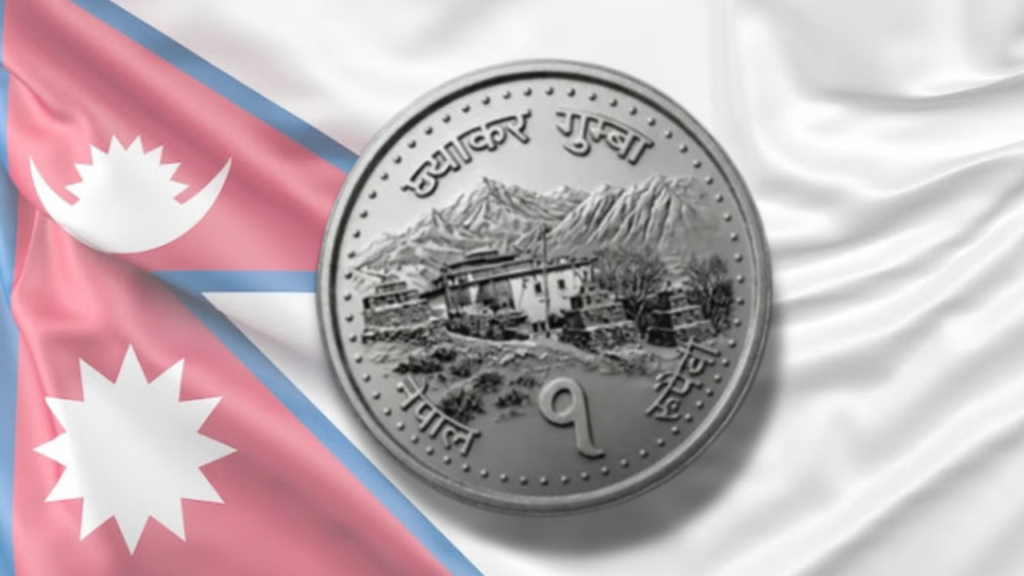
Recently, the Nepal government approved the minting of a redesigned Re 1 coin replacing the disputed Kalapani–Lipulekh–Limpiyadhura map with an ancient monastery.
Highlights of Nepal’s Re 1 Coin Redesign
- Cabinet Approval: Nepal’s Council of Ministers approved the Nepal Rastra Bank (NRB) proposal to issue a redesigned Re 1 coin in July 2026.
- The redesign applies specifically to the Re 1 coin. Re 2 coin continues to retain the earlier map.
- The NRB explained that the country’s complete new political map could no longer be accurately printed or legibly reproduced on the smaller surface area.
- The redesigned coin will gradually enter circulation alongside existing legal-tender coins.
- Redesign Features:
- The new design removed Nepal’s 2020 political map depicting Kalapani, Lipulekh and Limpiyadhura, regions claimed by Nepal but administered by India.
- The coin now features the Lo Ghyakar Monastery in Marang, Mustang, replacing the disputed territorial map.
- Lo Gekar Monastery (also known as Ghar Gompa) is the oldest monastery in Nepal’s Mustang region.
- It was built in the 8th century by the legendary Guru Rinpoche (Padmasambhava).
- It is a pivotal site for studying the transmission of Vajrayana Buddhism from India to Tibet.
- It is considered older than Tibet’s Samye Monastery.
- It is situated at an elevation of approximately 3,920 meters (about 12,860 feet) above sea level.
- Historical chronicles indicate that the Indian Buddhist scholar Atisa visited Lo Gekar on his way to Tibet in the 10th century.
- It belongs to the Nyingma school, which is the oldest of the major schools of Tibetan Buddhism.
- It has a modest footprint, featuring a central assembly hall enclosed by a covered ambulatory or circumambulation pathway.
- The sanctum contains life-sized statues of goddesses (notably one seated on a cow and another on a horse) as well as an imposing statue of Guru Rinpoche.
- The monastery is uniquely surrounded by 108 small chortens (stupas).
- The redesigned coin shifts from a mixed-metal alloy to stainless steel, reducing production costs, and simplifying large-scale minting for everyday circulation.
- The Re 1 coin’s weight has been reduced from 4 grams to 3.2 grams. Besides weight reduction, the coin size has also been decreased, enabling efficient metal usage.
- The redesigned coin changes from the previous yellow-toned appearance to a steel-white finish, creating a distinct visual identity.
- Significance: The removal of the 2020 disputed map signalling a symbolic reduction in diplomatic friction.
- India and Nepal share an approximately 1,751-km open border. Stable relations remain strategically important for Himalayan security, economic integration and regional stability.
- The decision could encourage renewed India–Nepal boundary dialogue through existing diplomatic mechanisms.
- The redesign may contribute to confidence-building, complementing cooperation in trade, connectivity, hydropower and people-to-people relations.
India–Nepal Territorial Dispute
- Claimed Regions: The India–Nepal territorial dispute centres on Kalapani, Lipulekh Pass and Limpiyadhura in the northwestern Himalayas at the India–Nepal–China tri-junction.
- The disputed area lies in the Upper Kumaon Himalayas, adjoining Pithoragarh district of Uttarakhand (India), Darchula district of Sudurpashchim Province (Nepal) and Tibet Autonomous Region (China).
- Kalapani lies near the headwaters of the Kali River, Lipulekh Pass is a high Himalayan pass at about 5,300 metres connecting India with Tibet.
- It serves as the shortest motorable route for the Kailash Mansarovar Yatra, facilitates India–China border trade, and forms part of India’s strategic logistics in the central Himalayas.
- Limpiyadhura lies further northwest. Together, the disputed territory covers about 372 sq km, though precise estimates vary slightly across sources.
- Following the 1962 India–China War, India stationed the Indo-Tibetan Border Police (ITBP) and other security forces in Kalapani.
- Control of Kalapani provides surveillance over important Himalayan routes and strengthens India’s northern border security architecture.
- Nepal’s Arguments: Nepal bases its claim primarily on the Treaty of Sugauli (1816) and numerous British-era maps prepared during the nineteenth century.
- The Treaty of Sugauli (1816), signed after the Anglo-Nepalese War (1814–1816).
- The treaty declared the Kali (Mahakali/Sharda) River as Nepal’s western boundary but did not define the river’s precise source nor attach an official map.
- According to Nepal, the treaty and these historical maps consistently identify Limpiyadhura as the source of the Kali River, thereby placing Kalapani, Lipulekh and Limpiyadhura inside Nepal.
- Kathmandu argues that any subsequent administrative changes by British India cannot override the original treaty.
- Nepal raised the issue in international forums, including statements at the United Nations General Assembly and during visits to friendly nations.
- The Treaty of Sugauli (1816), signed after the Anglo-Nepalese War (1814–1816).
- India’s Stand: India argues that the main Kali River originates near Kalapani, not Limpiyadhura.
- Maps, including the Survey of India maps from 1827, 1846, and 1920, show the Kali River originating near Lipulekh and Pankhagad stream.
- Based on this interpretation, the disputed territory falls within present-day Uttarakhand.
- India also relies on historical administrative records, revenue documents from the nineteenth century, census records, tax collection, continuous governance and long-standing administrative control to support its claim.
- Indian officials state that Nepal’s expanded claim lacks sufficient historical and legal basis and represents a unilateral enlargement of territorial claims.
- India also points out that the 1950 Treaty of Peace and Friendship between them allows for communication and negotiation, but does not change historical boundaries.
- Major Developments: After the 1962 conflict between India and China, the Lipulekh pass was closed but was reopened in 2015 to facilitate trade.
- The dispute intensified in 2015 after India and China agreed to expand border trade through Lipulekh without Nepal’s participation.
- In November 2019, India released a revised political map after reorganising Jammu & Kashmir, showing Kalapani within Uttarakhand, which Nepal strongly opposed.
- In May 2020, India inaugurated the 80 km road Dharchula–Lipulekh road, leading Nepal to issue diplomatic protests.
- In 2020, Nepal issued a new official political map incorporating Kalapani, Lipulekh and Limpiyadhura into its territory.
- Parliament subsequently passed a constitutional amendment incorporating this map into Schedule 3 of Nepal’s Constitution, giving constitutional status to its territorial claim.
- In 2025, India and China agreed to reopen border trade through Lipulekh, and in 2026, India resumed the Kailash Mansarovar Yatra through the pass.
- Nepal sent diplomatic notes to both India and China, objecting to trade, infrastructure and pilgrimage activities in the disputed area.
- India rejected Nepal’s objections, reiterating that such activities occur within Indian territory and that the claims are unsupported by historical evidence.
- Current Status: The dispute remains unresolved.
- India continues to exercise effective administrative control, while Nepal continues to assert constitutional and diplomatic claims.
- Both governments officially state that the issue should be resolved through bilateral dialogue, and neither side supports third-party mediation.
- Existing bilateral mechanisms remain available, although no final boundary settlement has yet been reached.
FAQs:
1. Why did Nepal redesign its Re 1 coin?
To replace the disputed map with a cultural heritage symbol and modernize coin specifications.
2. Which controversial map was removed from the new coin?
Nepal’s 2020 political map showing Kalapani, Lipulekh, and Limpiyadhura.
3. What is the Kalapani–Lipulekh–Limpiyadhura dispute?
A long-standing India–Nepal border dispute over approximately 372 sq km of Himalayan territory.
4. How does the new coin affect India–Nepal relations?
It symbolically eases tensions but does not change Nepal’s official territorial claims.
5. When was the redesigned Re 1 coin introduced?
The redesign was approved by Nepal’s Cabinet in July 2026.
6. Who approved the redesign of Nepal’s currency?
Nepal’s Council of Ministers, based on a Nepal Rastra Bank proposal.
Disclaimer: Information in this article is based on official announcements and public records. Regulations and implementation details may evolve over time.