




India Names Arunachal Places to Assert Border Sovereignty
| General Studies Paper II: India and its Neighbourhood |
Why in News?
Recently, India officially named 27 geographical locations in Arunachal Pradesh on official maps, reinforcing border sovereignty against Beijing’s territorial claims.
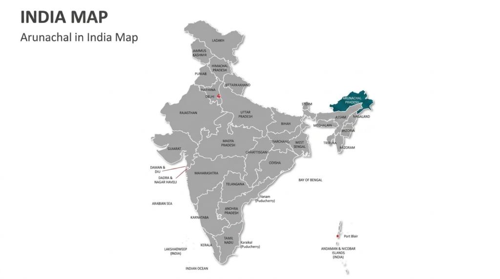
India’s Renaming of Arunachal Pradesh Locations
- Announcement: The Ministry of Home Affairs (MHA) announced that 27 places and geographical features in Arunachal Pradesh had been formally identified by their standard names on Survey of India maps.
- The names were reportedly finalised in consultation with the Arunachal Pradesh Government.
- The stated objective is accurate recognition, public awareness and uniform official cartographic records.
- Locations: Under these 27 locations:
- 21 are land locations: Longju, Maja, Bisa, Bara Kundun, Chhota Kundun, Dhan Bari, Pritnagar, Buddhamandir, Jairampur, Teritnagar, Ramnagar, Jaswant Garh, Sagar, Padma, Jyotinagar, Baisakhi, Chhota Ropuk, Bara Ropuk, Shivaji Nagar, Sunpura and Kamlang Nagar.
- 4 others are mountain passes: Dzo La, Riza La, Pukur La and Thag La.
- 1 High-altitude lake: Sambho Sarovar.
- 1 War memorial: Sher-e-Thapa Memorial.
- Significance:
- Longju: Located along the Line of Actual Control (LAC) in the Upper Subansiri district sector. A primary historical flashpoint.
- It was the site of the first major violent clash between Indian and Chinese troops in 1959, directly preceding the 1962 Sino-Indian War.
- Longju: Located along the Line of Actual Control (LAC) in the Upper Subansiri district sector. A primary historical flashpoint.
- Jairampur: Situated in the Changlang district towards the southeastern border of the state.
- Heavily historicized as a major logistics hub along the famous Stilwell Road (Ledo Road) constructed during World War II.
- Sher-e-Thapa Memorial: Located in the eastern sector of the state’s rugged mountain passes.
- An official state monument honoring the fierce bravery of Trilok Singh Thapa, a 1962 war hero who inflicted heavy casualties on invading forces.
- Maja: Maja, south of Longju, gained significance after the 1959 incident when India established a new post there.
- It illustrates India’s historical forward deployment and patrolling in the eastern sector.
- Bisa: It lies in the strategically sensitive Upper Subansiri region. Its importance arises principally from frontier geography, and border administration.
- Thag La: It is closely associated with the Namka Chu sector and the opening military phase of the 1962 India-China War.
- Other strategically important passes like Dzo La, Riza La, and Pukur La lie along the McMahon Line.
- Jaswant Garh: It commemorates Rifleman Jaswant Singh Rawat of 4 Garhwal Rifles, associated with India’s defence during the 1962 conflict.
- Sambho Sarovar, identified as a high-altitude glacial lake. It is a natural, high-altitude glacial water body representative of the Eastern Himalayas’ fragile and remote ecosystem.
- Kamlang Nagar: Located in eastern Arunachal, immediately adjacent to the pristine Kamlang Wildlife Sanctuary. A key eco-settlement representing India’s biodiversity conservation.
About Arunachal Pradesh & Related Facts
- Location: Arunachal Pradesh is India’s northeasternmost state, occupying 83,743 sq km and sharing international boundaries with Bhutan, China and Myanmar. Its capital is Itanagar.
- The state is predominantly mountainous and forms an important part of the Eastern Himalayas.
- Its northern boundary adjoins China, making Arunachal central to India’s border security and China policy.
- The region contains sensitive frontier sectors and strategically important mountain corridors.
- The eastern Himalayan boundary is associated with the McMahon Line, agreed between British India and Tibet at the 1914 Simla Convention.
- China rejects this boundary and claims Arunachal Pradesh, particularly describing it as “South Tibet.” India firmly regards Arunachal as an integral part of India.
- Statehood & Evolution: The region was historically known as the North-East Frontier Agency (NEFA).
- It became a Union Territory in 1972 and achieved full statehood on 20 February 1987 under the State of Arunachal Pradesh Act, 1986.
- It became the 24th state of the Indian Union.
- Geography: Arunachal contains major Himalayan ranges, deep valleys, forests and high-altitude landscapes.
- Rivers such as the Siang, Subansiri, Dibang, Lohit and Kameng drain the state and ultimately contribute to the Brahmaputra river system.
- Mount Kangto (also known as Kanggardo Rize) stands at 7,090 meters (some records note 7,042m or 7,060m).
- It is the highest peak in Arunachal Pradesh and forms part of the Eastern Himalayas on the border with Tibet.
- Biodiversity: The state is exceptionally rich in biodiversity, with multiple ecological zones.
- The official state portal identifies the Great Pied Hornbill as the state bird and the Hoolock Gibbon as its state animal.
- Tribal Diversity: Arunachal is characterised by remarkable ethnic and linguistic diversity.
- Major Scheduled Tribes include the Nyishi, Adi, Apatani, Galo, Monpa, Tagin, Mishmi, Wancho, Nocte and Tangsa, among others.
- Cultural Heritage: The state represents a meeting point of Tibetan-Buddhist, indigenous and other cultural traditions.
- Tawang Monastery, associated particularly with the Monpa community, is one of the region’s best-known cultural and religious landmarks.
- The state celebrates vibrant festivals such as Losar, Solung, Nyokum, and Dree.
- State Symbols: The state symbols are the Great Pied Hornbill as the bird, the Mithun as the animal, the Hollong as the tree, and the Foxtail Orchid as the flower.
- China’s Claim: China disputes the eastern sector of the India–China boundary and claims approximately 90,000 sq km of Indian territory in Arunachal Pradesh.
- China argues that the Tibetan representatives lacked authority to conclude a binding boundary settlement.
- Beijing frequently refers to Arunachal Pradesh as “Zangnan” or South Tibet and has repeatedly stated that it does not recognise the Indian state.
- China bases its claim on historical, tax, and cultural ties between the Tawang Monastery and Lhasa (Tibet).
- China released five consecutive batches of standardized Chinese names for locations inside Arunachal (2017, 2021, 2023, 2024, and May 2025).
- China is issuing stapled visas to athletes from Arunachal and detaining citizens using standard Indian passports transitively through China.
- India’s Counter-Strategy: India consistently maintains that Arunachal Pradesh was, is and will remain an integral part of India.
- India’s official position is that the entire state is an integral and inalienable part of India.
- New Delhi rejects China’s territorial claims as baseless and states that repeated assertions cannot alter India’s sovereignty.
- The inauguration of the Sela Tunnel provides year-round, unhindered tactical movement to Tawang, bypassing hazardous high-altitude passes.
- Extensive construction of the Arunachal Frontier Highway running parallel to the LAC to accelerate troop deployment capabilities.
- Vibrant Villages Programme (VVP), a direct antidote to China’s Xiaokang villages, this scheme funds frontier villages to prevent migration and act as a reliable civil-military eye on the border.
- In a direct response to China’s naming tactics, the MHA formally standardized and named 27 strategic locations on official Survey of India maps.
Frequently Asked Questions (FAQs):
1. Why has India assigned official names to 27 places?
India standardised names to reinforce official cartographic records, sovereignty, geographical recognition and administrative clarity.
2. Which 27 places received official names?
The 27 include 21 land areas, four mountain passes, one lake and one memorial, including Longju, Thag La and Jaswant Garh.
3. Why are place names important in the India-China dispute?
Names influence cartographic narratives and sovereignty signalling, though nomenclature alone cannot determine international territorial rights.
4. What is China’s position on Arunachal Pradesh?
China claims Arunachal Pradesh as “Zangnan” (South Tibet) and rejects India’s sovereignty over the territory.
5. How has India responded to China’s claims?
India rejects China’s claims, calls Arunachal Pradesh an integral part of India, and strengthens administration and border infrastructure.
6. Does assigning official names change India’s territorial rights?
No. Place-name standardisation does not independently create or alter territorial rights under international law.
Disclaimer: Information in this article is based on official announcements and public records. Regulations and implementation details may evolve over time.
| Also Read: Proposal to Rename West Bengal |