



China Expands Antelope Reef To Build Military Base
| General Studies Paper II: Effect of Policies & Politics of Countries on India’s Interests |
Why in News?
Recently, satellite data confirmed that China completed the first phase of a massive land reclamation campaign at Antelope Reef, creating strategic reach across disputed South China Sea waters.
What is Antelope Reef?
- About: Antelope Reef is a coral atoll formation located in the western Pacific. It is a reef/rock feature in the Paracel Islands of the South China Sea.
- It is also called Lingyang Jiao by China and Đá Hải Sâm by Vietnam.
- Location: The reef lies in the Crescent Group, in the southwestern Paracels, at approximately 16°27′45″N, 111°35′20″E.
- It is about 162 nautical miles from Sanya, Hainan, and roughly 216 nautical miles from Da Nang, Vietnam, giving it considerable strategic value.
- Naming: The feature was mapped and named in 1808 after the Antelope, a vessel belonging to the Bombay Marine of the British East India Company.
- The survey was executed under the command of Captain Daniel Ross.
- Dispute: It is occupied by China but claimed by Vietnam and Taiwan, making it part of the wider regional sovereignty dispute.
- Vietnam asserts historical ownership but China has exercised de facto control over the entire Paracel archipelago since the 1974 Battle of the Paracel Islands, when it forcefully expelled South Vietnamese forces.
- Vietnam continues to regard the islands as Vietnamese territory and has repeatedly protested Chinese activities there.
- Legal Status: An international tribunal ruling in 2016 under the United Nations Convention on the Law of the Sea (UNCLOS) rejected China’s sweeping territorial claims within its “nine-dash line“.
- Significance:
- Antelope is a coral reef/atoll-type maritime feature containing a large lagoon.
- Its lagoon is particularly significant because its sheltered waters can support harbour and maritime-logistics infrastructure.
- Prior to human alteration, Antelope Reef was a teardrop-shaped coral structure enclosing a central lagoon.
- Its location provides potential advantages for maritime surveillance, naval logistics, air operations and force projection.
- Antelope is a coral reef/atoll-type maritime feature containing a large lagoon.
- Artificial-Island: China launched its most aggressive land reclamation campaign since 2017.
- In October 2025, China resumed large-scale dredging and land reclamation after several years of relative inactivity in island-building.
- Satellite imagery from August 2026 confirmed the completion of the project’s first construction phase.
- Satellite imagery showed a newly built artificial island of about 1,500 acres.
- The island features a 3-kilometer straight coastline engineered along its northwestern edge.
- The new land feature spans nearly 6 kilometers in length and integrates a helicopter pad, operational barracks, and a 680-meter wharf.
- Satellite imagery has revealed jetties, a reinforced quay, a helipad, more than 50 structures and construction facilities.
- Defense analysts from the Asia Maritime Transparency Initiative (AMTI) evaluate this sector as highly capable of hosting a 10,000-foot military-grade airstrip for fighter jets.
- Also new construction was detected on Yagong Island, located 14 kilometers northeast of Antelope Reef.
- Satellite data reveals three-pronged layouts, identified as an early warning radar facility.
- The development contributes to the broader militarisation of disputed features in the South China Sea.
About South China Sea
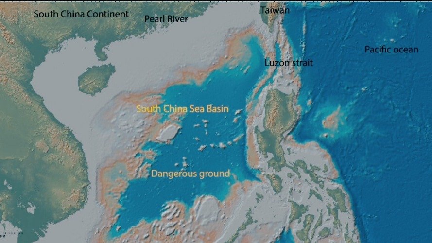
- Location: The South China Sea (SCS) is a semi-enclosed sea of roughly 3.5 million sq km.
- It is bordered by China and Taiwan to the north, the Indo-Chinese peninsula (including Vietnam) to the west, Indonesia and Brunei to the south, and the Philippines to the east.
- It connects major Indo-Pacific maritime routes and contains important fishing grounds, coral ecosystems and potential hydrocarbon resources.
- It is linked to the East China Sea via the Taiwan Strait, the Philippine Sea via the Luzon Strait, and the Indian Ocean/Andaman Sea via the strategic Strait of Malacca.
- Dispute: The dispute has two interconnected dimensions: territorial sovereignty over islands, reefs and shoals, and maritime entitlements such as territorial seas, EEZs and continental shelves.
- The dispute revolves around several geographically distinct island chains, reefs, and shoals: Spratly Islands, Paracel Islands, Scarborough Shoal and Natuna Islands.
- China asserts extensive rights in the SCS through its historically framed nine-dash line.
- China’s “Nine-Dash Line” is a historical demarcation dating back to a 1947 map. Through this line, Beijing claims sovereignty over nearly 90% of the South China Sea.
- China, Taiwan and Vietnam claim the Paracel and Spratly Islands, while China, Taiwan, Vietnam, the Philippines, Malaysia and Brunei have overlapping claims involving parts of the Spratlys and surrounding maritime zones.
- Indonesia is not a claimant to the Spratly Islands but has rejected Chinese claims overlapping its EEZ around the Natuna Islands.
- Major friction points include Scarborough Shoal, Second Thomas Shoal, Mischief Reef, Fiery Cross Reef, Subi Reef, Paracel Islands and Reed Bank.
- Drivers: These locations can affect fishing, resource exploration, surveillance, military logistics and maritime presence.
- The sea contains an estimated 3.6 billion barrels of oil, 40.3 trillion cubic feet of natural gas, and rich rare-earth mineral wealth.
- It also holds 12% of the global fish catch, generating $100 billion annually.
- China employs “salami-slicing” tactics—gradual, small-scale provocations like deployment of its maritime militia and extensive land reclamation (creating over 3,200 acres of artificial land since 2013) to build airstrips and military fortifications.
- Intervention:
- The Philippines initiated UNCLOS Annex VII arbitration in 2013, and the tribunal issued its final award on 12 July 2016.
- It examined historic rights, maritime entitlements, the legal status of features and China’s conduct—but did not decide sovereignty over islands.
- The tribunal concluded that there was no legal basis for China to claim historic rights to resources within the nine-dash line where such claims exceeded UNCLOS entitlements.
- UNCLOS defines territorial waters (12 nautical miles) and Exclusive Economic Zones (200 nautical miles) originating from recognized land features.
- Article 121 distinguishes fully habitable islands from rocks or low-tide elevations, which do not generate an EEZ or continental shelf.
- China rejects the award, calling it legally invalid and non-binding.
- Association of Southeast Asian Nations (ASEAN) seeks peaceful dispute management through dialogue, the 2002 Declaration on the Conduct of Parties (DOC) and negotiations toward a Code of Conduct (COC).
- However, ASEAN’s consensus-based approach faces difficulty because member states have different strategic and economic relationships with China.
- The United States does not claim territory in the SCS but conducts Freedom of Navigation Operations (FONOPs) and maintains defence partnerships, particularly with the Philippines.
- Western alliances like AUKUS and minilaterals like the US-Japan-Philippines triad frequently execute joint naval drills to deter Chinese aggression.
- The Philippines initiated UNCLOS Annex VII arbitration in 2013, and the tribunal issued its final award on 12 July 2016.
Implications for India
- Trade and Economic Security: Over 55% of India’s sea-borne trade transits through the South China Sea and the Malacca Strait.
- Any blockades, shipping disruptions, or conflict-induced insurance hikes would directly harm Indian macroeconomic stability.
- Energy Interests (ONGC Videsh): India has commercial stakes in oil and gas exploration blocks off the coast of Vietnam (e.g., Block 128).
- Chinese naval intimidation of these operations directly challenges India’s energy diplomacy.
- Geopolitical Counter-Ballast: China’s aggressive expansionism in the Indian Ocean (the “String of Pearls” strategy) is met by India expanding its presence in China’s backyard.
- Maintaining an active strategic footprint in the SCS ensures a credible counter-leverage against Chinese pressure along the Line of Actual Control (LAC).
- Defense and Capacity Building: India has emerged as a security provider to Southeast Asian states.
- This is underscored by the export of BrahMos supersonic cruise missiles to the Philippines, upgrading logistics access to Vietnam’s ports, and strengthening the Quad framework (India, US, Japan, Australia) to guarantee a “Free and Open Indo-Pacific.”
Frequently Asked Questions (FAQs):
1. What is Antelope Reef?
Antelope Reef is a disputed reef in the Paracel Islands, controlled by China and claimed by Vietnam and Taiwan.
2. Why is China expanding Antelope Reef?
China is expanding it to strengthen maritime presence, surveillance, logistics and potential military capabilities in the South China Sea.
3. Where is Antelope Reef located?
It lies in the Crescent Group of the southwestern Paracels, about 162 nautical miles from Sanya and 216 from Da Nang.
4. How much has Antelope Reef expanded?
China has reclaimed approximately 1,500 acres, creating one of its largest artificial islands in the region.
5. What is China’s land reclamation activity?
China uses dredging and landfill to transform reefs into artificial islands supporting ports, runways, buildings and surveillance infrastructure.
6. Why is Antelope Reef strategically important to China?
Its large lagoon, location and potential runway could support naval vessels, surveillance, logistics and broader sea-air control operations.
Disclaimer: Information in this article is based on official announcements and public records. Regulations and implementation details may evolve over time.