




Cyclone Murasu: Origin, IMD Alert, Landfall and Preparations
| General Studies Paper I: Geography, Natural Phenomena, Disaster Management |
Why in News?
Recently, Cyclone Murasu intensified into a severe cyclonic storm over the Bay of Bengal, prompting India Meteorological Department (IMD) red alerts.
Cyclone Murasu 2026 Highlights
- Origin & Formation: Cyclone Murasu developed from a well-marked low-pressure area over the southeast Bay of Bengal and adjoining Andaman Sea.
- It gradually intensified into a depression on 31 October 2026, followed by a deep depression and then a cyclonic storm on 1 November.
- The system moved west-northwestwards under favourable atmospheric conditions.
- Warm sea-surface temperatures, sufficient atmospheric moisture and favourable wind patterns supported intensification.
- It registers a central pressure of 986 hPa and maintains high sea wave heights of seven meters.
- Wind structures feature a strong cloud mass, tracked by India’s INSAT-3DS satellite.
- Naming: Cyclone Murasu was named by India. Murasu is a traditional Tamil name meaning “war drum”.
- It is a tropical system in the North Indian Ocean basin.
- IMD Alert: The India Meteorological Department (IMD) issued a critical RedMessage cyclone warning for the southern coastal districts.
- IMD classified the weather system as a Severe Cyclonic Storm.
- Track & Landfall: The storm moves northwest at a steady speed of 22 kmph. The core path directly vectors toward the south Andhra Pradesh coast.
- Its expected landfall zone is between Nellore and Narsapur, near Ongole, during late 2 November and early 3 November.
- Forecast sustained winds are 100–110 kmph, with gusts reaching 120 kmph.
- A severe storm surge warning predicts tides 1.0 to 1.5 meters above astronomical levels.
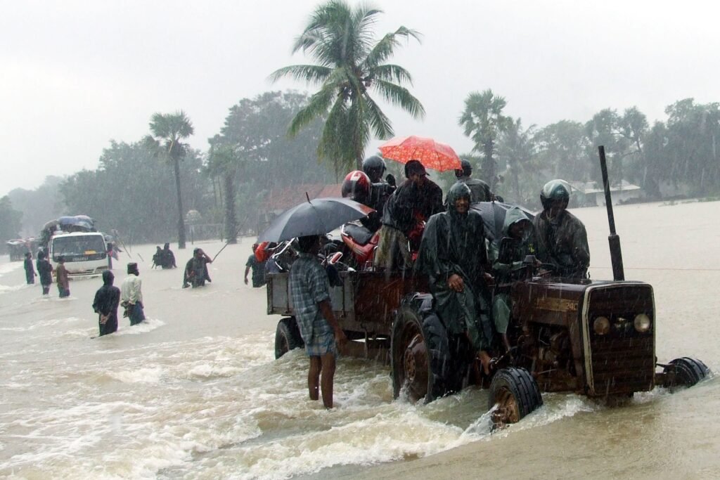
- Impacts: Severe coastal inundation is expected in low-lying zones during landfall.
- The highest vulnerability centers around the Bapatla, Krishna, Guntur, and Prakasam districts.
- Flash floods, uprooted trees, and damaged thatched structures pose major disaster risks across these regions.
- The sudden double-strike following Cyclone Arnab compromises regional environmental resilience.
- Extensive saltwater flooding ruins fertile agricultural standing crops. Prolonged commercial closures, broken transport grids, and mandatory rehabilitation costs will drive heavy regional economic losses.
- Preparation: India’s National Disaster Management framework triggered active emergency control hubs.
- Andhra Pradesh deployed six National Disaster Response Force (NDRF) and seven SDRF teams for immediate rescue operations.
- Authorities cancelled local train/flight schedules and evacuated vulnerable families. A strict fisherman warning bans all maritime activities until November 4.
- Neighboring Odisha placed southern collectors on high alert, shutting schools in Ganjam and opening Balimela reservoir gates.
- In Tamil Nadu, authorities ordered the closure of schools and colleges in Chennai and Tiruvallur due to heavy rainfall.
- Up to eleven flights were cancelled at Chennai International Airport.
What is a Cyclone?
- About: A cyclone is a large-scale system of air that rotates inward around a strong low-pressure center.
- In the Northern Hemisphere, the winds spin counterclockwise, while in the Southern Hemisphere, they rotate clockwise.
- They act as atmospheric heat engines, transferring excess thermal energy from the tropics to polar regions.
- Types: Tropical cyclones develop exclusively over warm tropical oceans (>26.5°C) and draw energy from latent heat of condensation. They possess a calm, cloudless “eye” at the center.
- Conversely, temperate cyclones (extra-tropical) form in mid-latitudes due to the collision of contrasting air masses, creating distinct frontal systems.
- Formation Conditions: For a tropical cyclone to form, several factors must align.
- These include a high sea surface temperature, the presence of the Coriolis force to initiate rotation (absent at the equator), high humidity in the troposphere, and low vertical wind shear to prevent the storm structure from tearing apart.
- Structure: The structure consists of the Eye, a low-pressure zone of subsidence and calm weather.
- Surrounding it is the Eye Wall, containing the most violent winds and heaviest rainfall.
- Spiral rainbands radiate outward, driving severe convective activity and moisture transport across thousands of kilometers.
- Landfall and Dissipation: Landfall occurs when the storm moves from ocean to land.
- Once cut off from its primary moisture and moisture-energy source—the warm ocean—the cyclone undergoes rapid dissipation. Friction over land surfaces further weakens the wind circulation.
- Impact: Cyclones cause mass devastation through three main drivers. Storm surges represent the abnormal rise of sea level pushing inland.
- Torrential rainfall triggers widespread inland flooding and landslides. High-velocity winds destroy infrastructure, communication networks, and standing crops.
- Naming: The World Meteorological Organization (WMO) oversees classification based on maximum sustained wind speed.
- Naming is managed by regional bodies like the IMD (India Meteorological Department) for the North Indian Ocean.
- Names are given using pre-designated sequential lists contributed by member nations to avoid confusion.
- Tropical cyclones are given different regional names based on their geographic location.
- They are called Hurricanes in the North Atlantic and Eastern Pacific, Typhoons in the Western Pacific, and simply Cyclones in the Indian Ocean and Southern Pacific.
- Warning Systems: The IMD uses a four-stage color-coded alert system.
- Pre-Cyclone Watch (Yellow) signals early warnings.
- Cyclone Alert (Orange) issues 48 hours in advance. Cyclone Warning (Red) comes 24 hours prior, followed by the Post-Landfall Outlook managing safety during steps of evacuation and disaster response.
- Precautions: Follow official alerts, evacuate when instructed, avoid beaches and floodwaters, secure homes, stock essentials and switch off electricity during flooding.
Frequently Asked Questions (FAQs):
1. What is Cyclone Murasu and where is it currently located?
Cyclone Murasu is a Severe Cyclonic Storm over the west-central Bay of Bengal, moving northwestwards towards Andhra Pradesh.
2. When is Cyclone Murasu expected to make landfall?
IMD forecasts landfall between Nellore and Narsapur, from late November 2 to early November 3, 2026.
3. Which areas of Andhra Pradesh are likely to be affected by Cyclone Murasu?
Nellore, Tirupati, Prakasam, Bapatla, Krishna and adjoining coastal districts face potential heavy rainfall, strong winds and flooding.
4. What warnings has the IMD issued regarding Cyclone Murasu?
IMD issued a Red Message, warning of 100–110 kmph winds, gusts up to 120 kmph and extremely heavy rainfall.
Disclaimer: Information in this article is based on official announcements and public records. Details may evolve over time.
| Also Read: Cyclone Arnab 2026 |